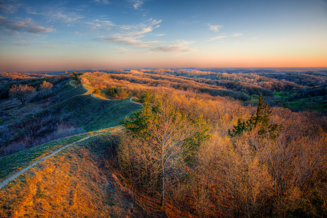
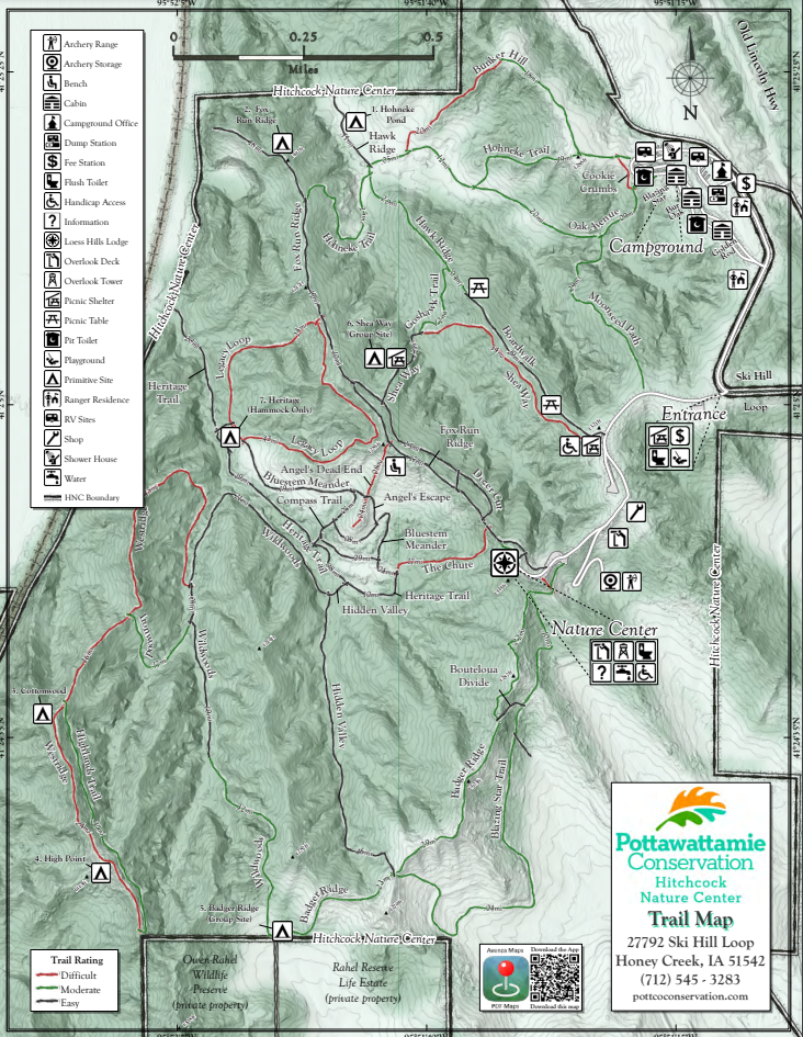
Trails network together so visitors can be creative to enjoy any length of hike they desire. Due to the rugged terrain of the Loess Hills, the trails vary from easy ridgeline walks to difficult climbs. Trail maps can be found at Fox Run Ridge, Badger Ridge, and Hohneke trailheads, or at the Loess Hills Lodge during gallery hours. It's difficult to create an easy loop at Hitchcock because at some point you will have to descend steeply into a valley or climb steeply onto a ridge. If you're looking for an easy family-friendly hike, do an out-and-back hike starting from the Badger Ridge or Fox Run Ridge trailheads in the parking lot below the Loess Hills Lodge. Another option is the ADA-accessible boardwalk that ends at Hawk Ridge.
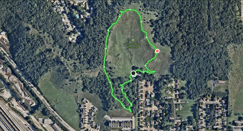
Vincent Bluff State Preserve is a cooperative venture between the City of Council Bluffs, Iowa Natural Heritage Foundation, and the Loess Hills Preservation Society to preserve a unique urban prairie in the Loess Hills. The preserve is located in the heart of Council Bluffs. Today, Vincent Bluff Prairie Preserve stands as the only truly urban prairie preserve in the state of Iowa, and likewise, is a great example of Loess Hills prairie, oak savanna, and eastern deciduous forest ecosystems. A footpath begins at the shelter near the parking lot and climbs steeply to the top of the prairie ridge. The climb is short but strenuous. You can follow the GPX track below to hike a loop, or just wander along the ridge enjoying the views and native flora. 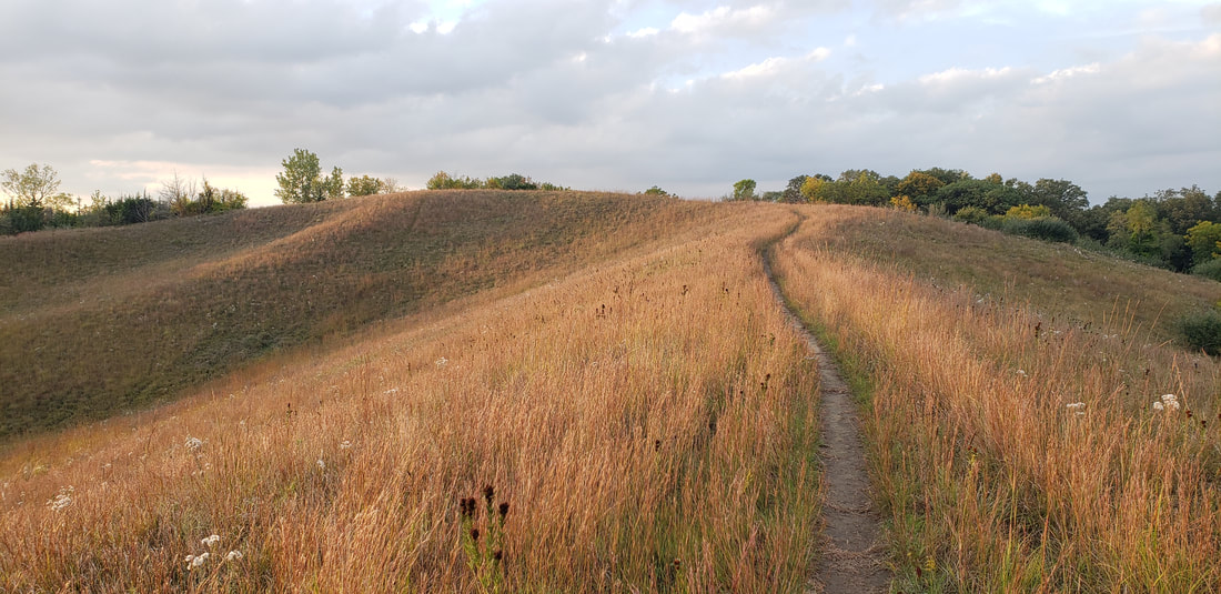 Vincent Bluff State Preserve (photo by Lance Brisbois)
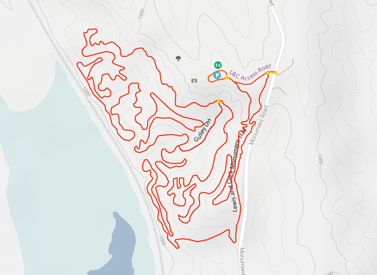
Dedicated in 1936 to honor the Corps of Discovery, Lewis & Clark Monument Park has a small observation deck and two large commemorative stone markers, quarried from the Folsom Quarry in Vermont and created by sculptor Harry E. Stinson and architect George L. Horner. The images and text on the markers explain Lewis and Clark’s meeting with local Oto and Missouri Indians. (The actual site of the meeting took place on the west side of the Missouri about 10 miles north of Omaha near today’s Fort Calhoun, Nebraska.) The monument stands atop a ridge of the Loess Hills, which run along much of the western edge of Iowa. For this reason, mountain bikers enjoy the challenging route through the heavy woods of the park, hikers appreciate the nearby trails, and aerial enthusiasts love the panoramic view of planes landing at Omaha’s Eppley Airfield just across the Missouri. Trails Have Our Respect (THOR) maintains the mountain bike trails. 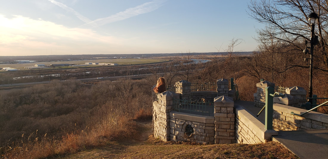 Lewis and Clark Monument Park
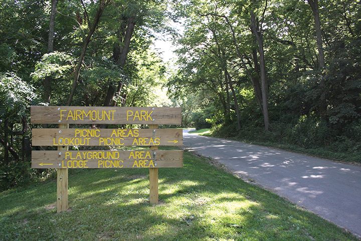 Fairmount Park (photo: Council Bluffs Fairmount Park Neighborhood Association) Fairmount Park (East Graham Ave and Park Entrance) hiking trails wind through the hills. At Fairmount Park, you'll also find a scenic overlook, a playground, a splash pad, a firepit, picnic shelters, and ample parking. Gibraltar Trailhead (9th Ave and High St) has picnic tables and direct access to the Fairmount Park hiking trails making it a great place to meet up with friends.
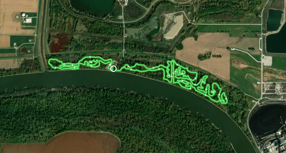
These trails connect to the trail system that runs throughout Council Bluffs including the Wabash Trace Trail and the Bob Kerry Pedestrian Bridge. There are also eight miles of unpaved trails perfectly suited for mountain biking located on either side of the Missouri River access on the south side of the park.  Lake Manawa State Park (photo by Chris Lind, Instagram @boipinoy) The mountain bike trails along the Missouri River just south of Lake Manawa are also hiker-friendly. The area is right along the river, so whenever there is a flood the trails will likely be impassable and damaged. The trails are maintained by the THOR group.
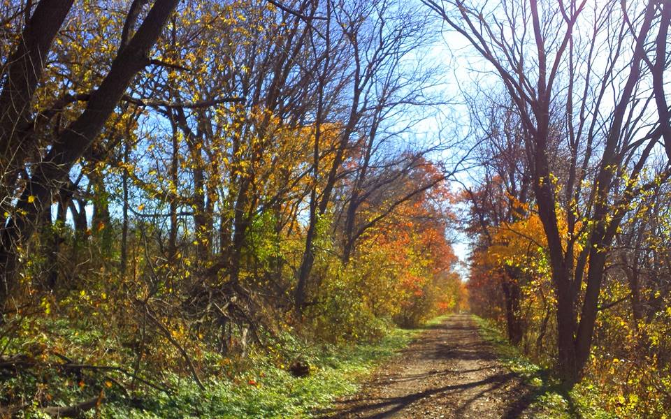
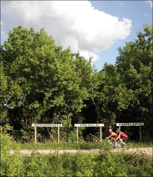
Wabash Trace Nature TrailWhile it's mostly known as a bike trail, the Wabash Trace Nature Trail is another opportunity for hikers to explore Pottawattamie County. The northern terminus of the trail is located in Pottawattamie County on the very southern boundary of Council Bluffs. The level grade makes it a nice option for a leisurely out-and-back hike from the Iowa West Foundation Trailhead, especially in fall when the leaves are turning colors.
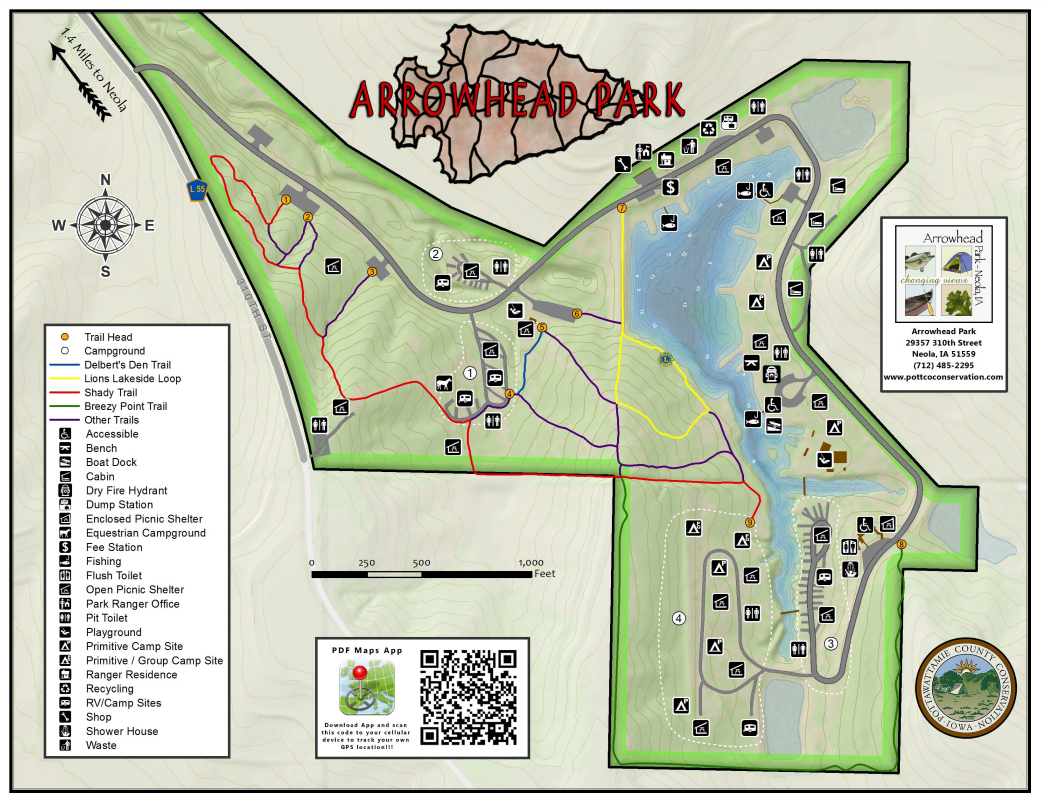
 Arrowhead Park and Botna Bend Park
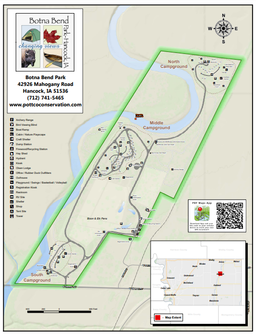 Botna Bend Park Hiking the Byways is a regular series by Golden Hills RC&D that features publicly accessible lands open to hiking on the three scenic byways in western Iowa that Golden Hills RC&D coordinates: Glacial Trail Scenic Byway, Loess Hills National Scenic Byway, and Western Skies Scenic Byway. Each Friday a blog post covers hiking areas in one county on one of the aforementioned byways. For questions about hiking on the byways, contact Seth Brooks (seth.brooks@goldenhillsrcd.org).
0 Comments
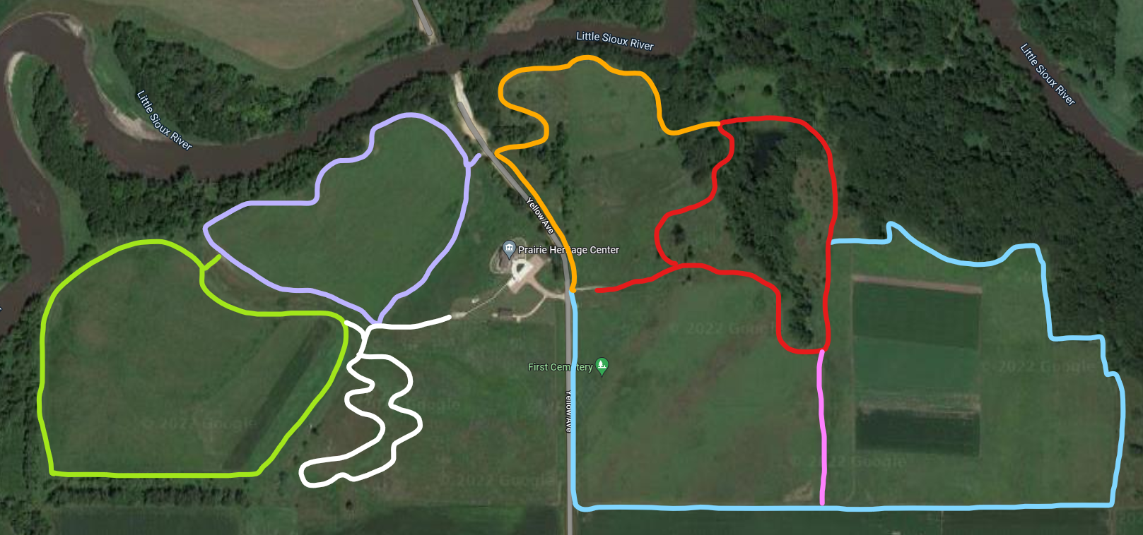
The purpose of the Prairie Heritage Center is to provide environmental education as it relates to the prairie and the county, to preserve and protect our prairie heritage, and to encourage economic development with regards to recreation and historic exploration. Every season of the year is a great one on the prairie! The Prairie Heritage Center opened its doors to the public on November 28, 2006. Over 100,000 people have visited the center since that time. They have come from all 50 states and over 26 foreign countries. It is a great place to enjoy educational and interactive displays, hike the trails, savor the wildflowers, and engage in bird and wildlife watching. Visit the Prairie Heritage Center and check out all the things to do! text source: O'Brien County Conservation 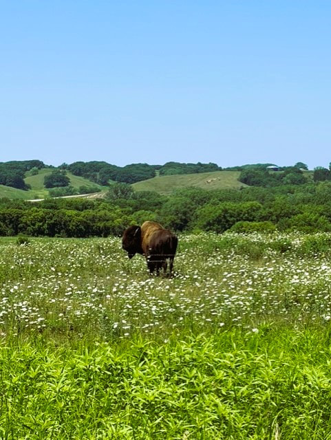 Bison at the Prairie Heritage Center (photo by O'Brien County Conservation)
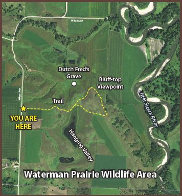
The section of Waterman Prairie south of Highway 10 offers an accessible prairie experience for byway visitors. A parking lot on Wilson Avenue, 1½ miles south of Highway 10, leads to a trail that meanders through prairie-covered ridges with spectacular vistas of the Little Sioux River valley. The Iowa Department of Natural Resources is restoring the prairie to its original plant community.
 Waterman Prairie (photo by Lance Brisbois)
 Dog Creek Park (photo by Lance Brisbois)
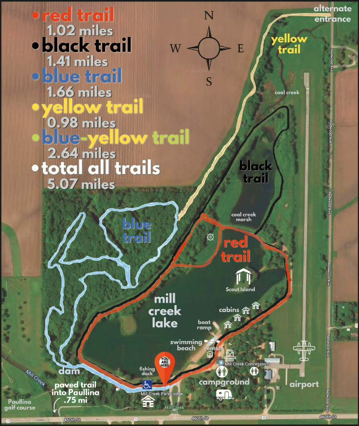
There is something for every outdoor lover at Mill Creek State Park including camping, swimming, hiking, a playground, electric boating, picnicking, and even cabin rentals. Fishing is also a popular activity, giving anglers a chance to catch largemouth bass, sunfish, channel catfish, crappie and yellow perch. Mill Creek Park is located just 1/2 mile east of Paullina on Iowa Highway 10. 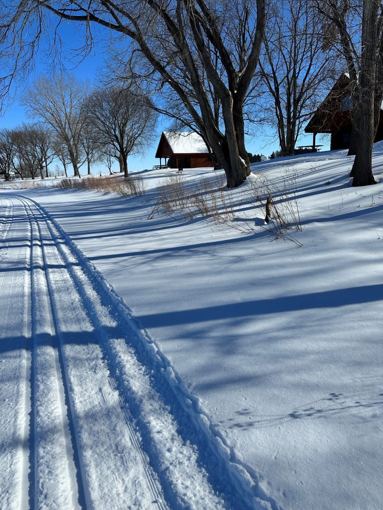 Mill Creek Park features groomed cross-country ski trails in winter.
 Tjossem Park (photo by O'Brien County Conservation)
 McCormack Area Hiking the Byways is a regular series by Golden Hills RC&D that features publicly accessible lands open to hiking on the three scenic byways in western Iowa that Golden Hills RC&D coordinates: Glacial Trail Scenic Byway, Loess Hills National Scenic Byway, and Western Skies Scenic Byway. Each Friday a blog post covers hiking areas in one county on one of the aforementioned byways. For questions about hiking on the byways, contact Seth Brooks (seth.brooks@goldenhillsrcd.org).
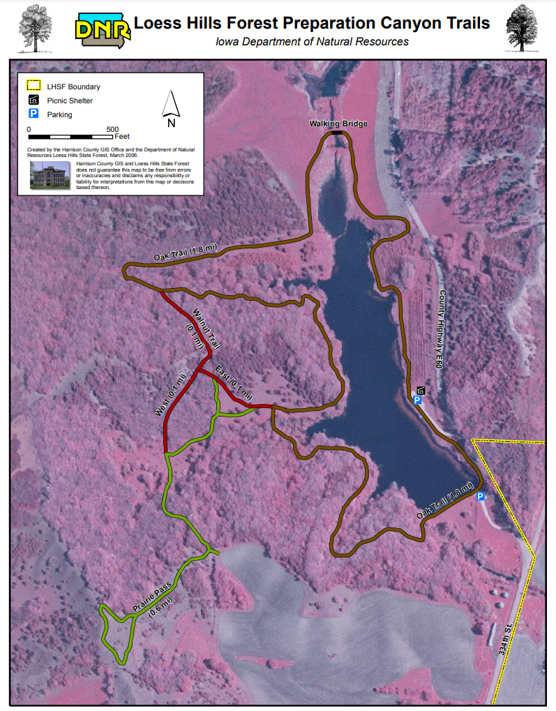
 LHSF Preparation Canyon Unit (photo © 2016 Kenneth West)
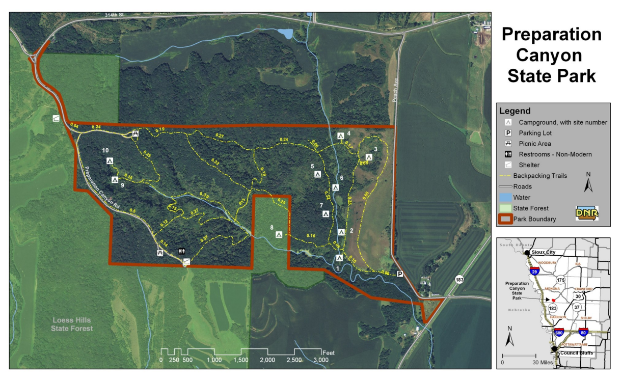
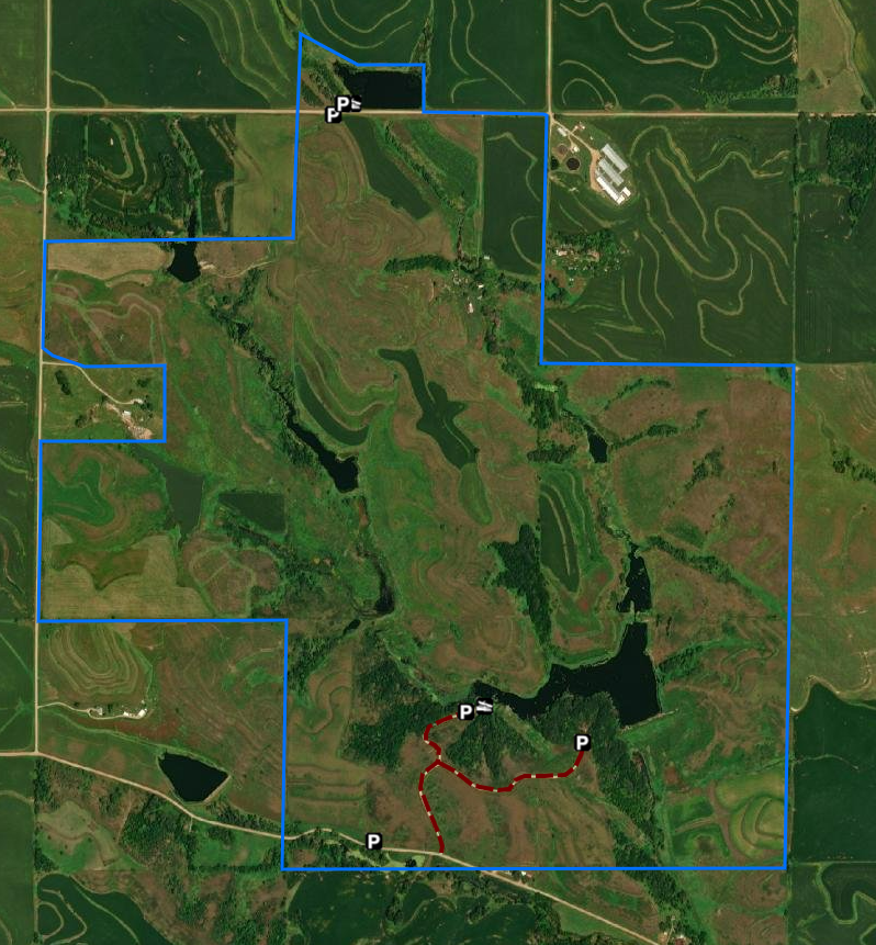
Preparation Canyon State Park, in the heart of the Loess Hills in western Iowa, encompasses 344 acres, including what used to be the town of Preparation. Today, Preparation Canyon is a quiet enclave offering backcountry hiking, picnicking, and beautiful views of the unique Loess Hills. In 1853, Charles B. Thompson broke from the Utah-bound Mormon wagon trail and settled in this area. At one point, Preparation had sixty-seven houses, a school, newspaper, post office, skating rink and blacksmith shop. But by 1900, the town had all but faded away. The land was sold by descendants of the original settlers to the state of Iowa in parcels during the mid-20th century and became the state park. Hike on one of the several trails that wind through the rugged Loess Hills. The backcountry trails follow hills and valleys, leading to a nature study area and the hike-in camping sites. Hikers should be prepared for rough terrain and loose soil with sturdy hiking shoes and appropriate gear. Camp in one of ten hike-in camping sites, which are some of the only hike-in sites in the Iowa state park system. The trailhead to the hike-in sites is located in the southeast corner of the park. The sites each have a table and fire ring, but no bathroom facilities. Registration is on a first-come first-served basis with self-registration in the east parking lot. text source: Iowa DNR
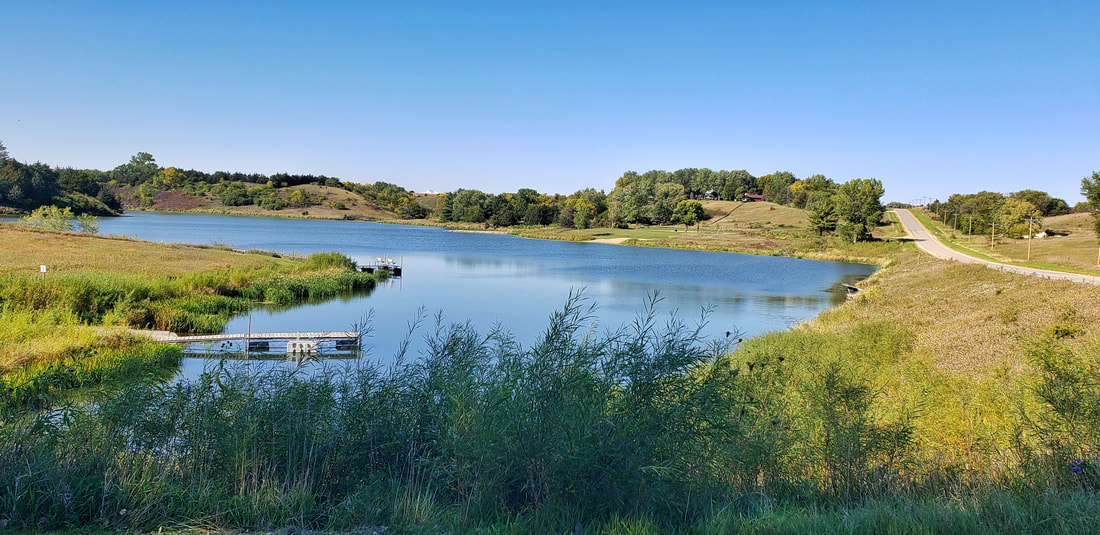
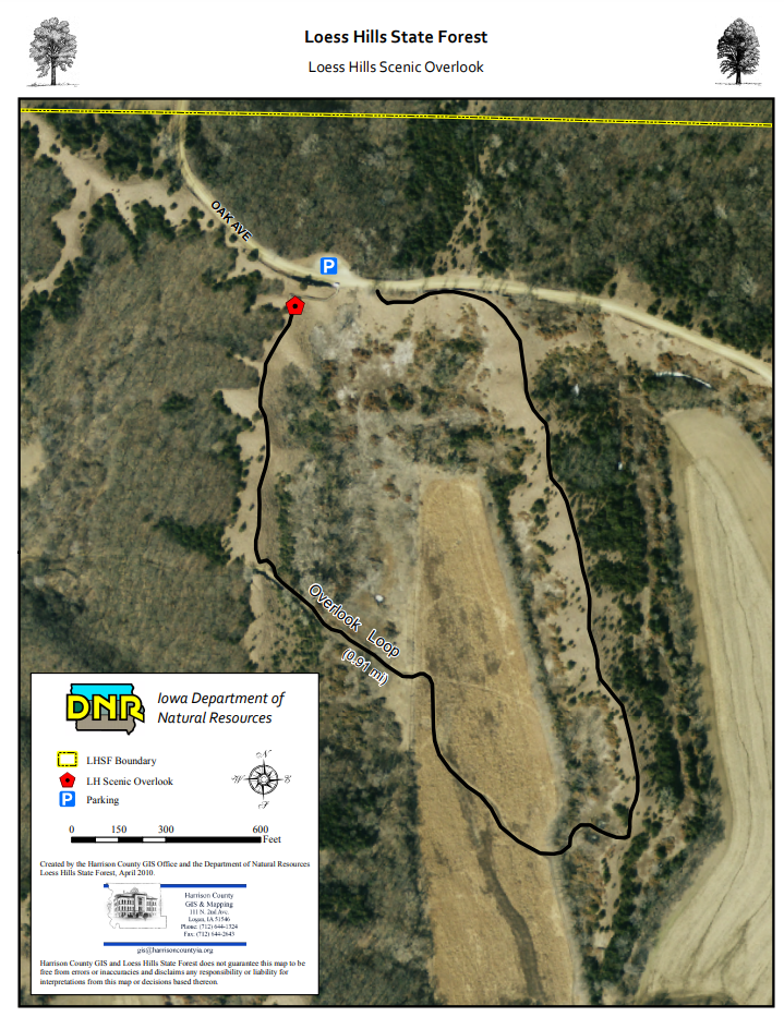
 Loess Hills Scenic Overlook (photo © 2016 Kenneth West)  Jones Creek Pond (photo by Lance Brisbois)
 Primitive campsite at Jones Creek Pond (photo by Seth Brooks)
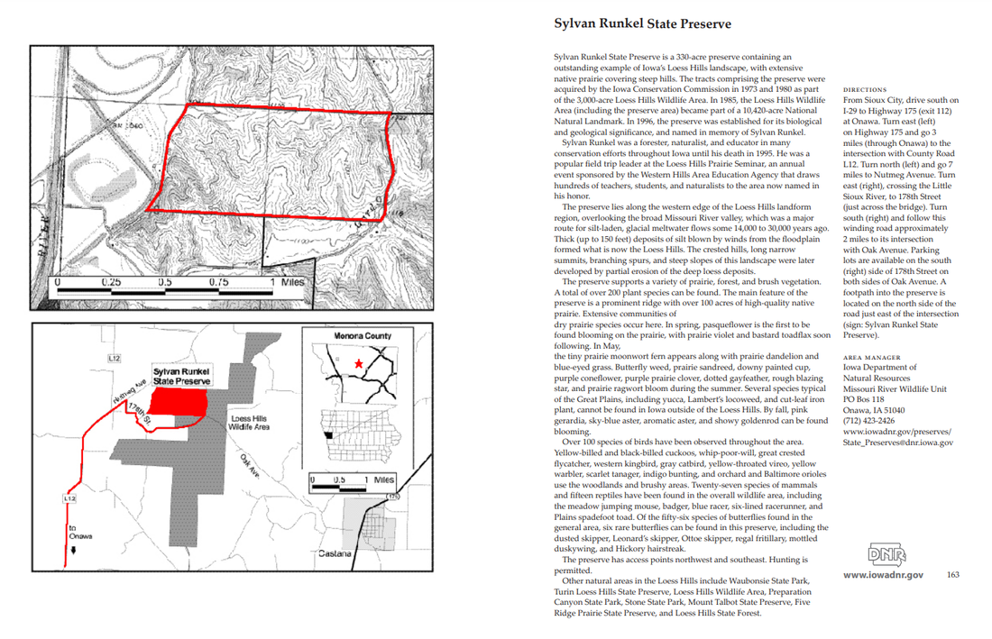
Sylvan Runkel State Preserve is a 330-acre preserve containing an outstanding example of Iowa’s Loess Hills landscape, with extensive native prairie covering steep hills. The tracts comprising the preserve were acquired by the Iowa Conservation Commission in 1973 and 1980 as part of the 3,000-acre Loess Hills Wildlife Area. In 1985, the Loess Hills Wildlife Area (including the preserve area) became part of a 10,420-acre National Natural Landmark. In 1996, the preserve was established for its biological and geological significance, and named in memory of Sylvan Runkel. 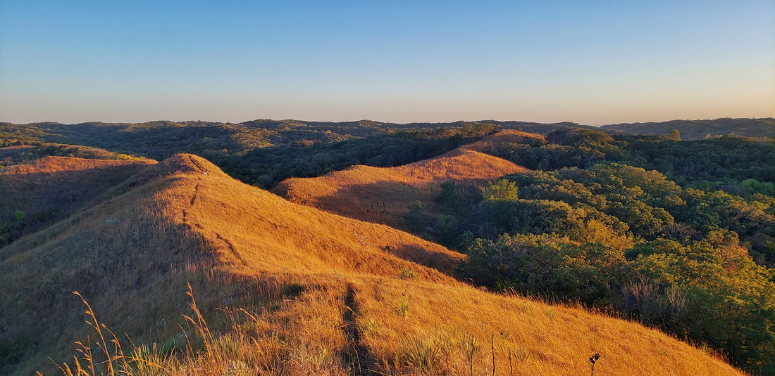 Sylvan Runkel State Preserve (photo by Lance Brisbois)
A number of Iowa threatened or endangered animals make their home here including the northern grasshopper mouse, plains pocket mouse and spadefoot toad. Wild turkeys and prairie chickens have been reintroduced. White-tail deer, fox squirrel, cottontail rabbit, coyote, raccoon and badger are common. Turkey vultures, bobwhite quail, ring-necked pheasant, whip-poor-will and many songbirds also exist in good populations. Controlled burns prevent brush and tree invasion and stimulate growth of prairie plants. The Loess Hills Prairie Seminar is held here every summer (intersection of Oak Avenue and 178th St). Before visiting a public wildlife area, please check out Chapter 51 : Wildlife Management Areas.  The Loess Hills Prairie Seminar is held at the wildlife area every summer (photo by Lance Brisbois)
 Turin Preserve Wildlife Area (photo by Golden Hills RC&D) Turin Preserve Wildlife Area is a 220-acre area featuring a rugged Loess Hills landscape with an abrupt west-facing ridge. It is located in the southern unit of the 3,000-acre Loess Hills Wildlife Area, 2 miles north of Turin and 7.5 miles east of Onawa in Monona County. The Iowa Conservation Commission purchased the area in 1974. In 1978, the area was dedicated as a biological and geological state preserve and became part of a National Natural Landmark in 1986. Before visiting a public wildlife area, please check out Chapter 51 : Wildlife Management Areas.
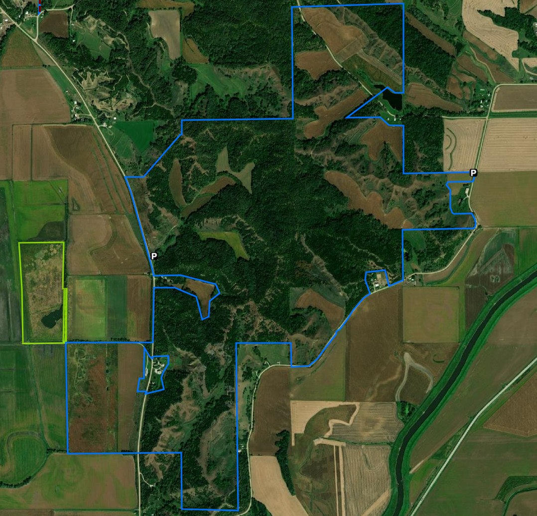
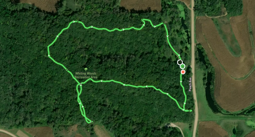
This 80-acre tract of dense native timber is located 4 miles southwest of Mapleton and just east of the Loess Hills Scenic Byway on Peach Avenue. Approximately 10 acres have been developed for camping, picnicking, hiking, and nature studies. A 1.6 mile trail takes you around the whole timber, with four benches for stopping and relaxing along the way. An open shelter house, 3 camping pads with 30 amp hook-ups, drinking water, and vault type toilet facilities are available. Upright/ground grills and picnic tables are also available. Whiting Woods is an excellent place to view wildlife and provides great hunting opportunities. Electric campsites are $20.00 per night, non-electric are $15.00 per night. A 10:30 curfew is enforced for all visitors. We currently do not take reservations for camping at this park as it is first come, first serve. text source: Monona County Conservation 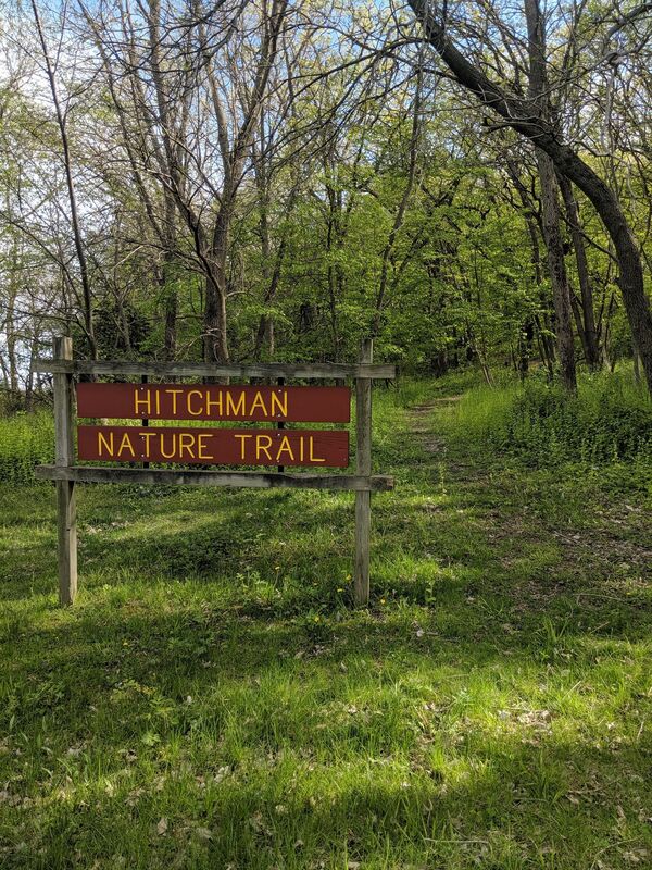 Hitchman Nature Trail at Whiting Woods (photo by Seth Brooks) Other hiking opportunitiesThe following areas, managed by Monona County Conservation, also allow hiking. Check the linked websites for more information. Masters Prairie Trail This linear park is an abandoned railroad right of way, which consisting of 24 acres that have been smoothed and planted to native short grasses and wildflowers. The two-mile trail begins on the west side of the Maple River and follows Hwy. 141 to the west. It was purchased from the Rail Road in 1990, with money from NIPCO in return for a permanent easement for their power lines. Hunting is not allowed. Gramm Wetland Gramm Wetland has a popular 2-mile walking trail. Beaver Run Wildlife Area Davis Wetland Hiking the Byways is a regular series by Golden Hills RC&D that features publicly accessible lands open to hiking on the three scenic byways in western Iowa that Golden Hills RC&D coordinates: Glacial Trail Scenic Byway, Loess Hills National Scenic Byway, and Western Skies Scenic Byway. Each Friday a blog post covers hiking areas in one county on one of the aforementioned byways. For questions about hiking on the byways, contact Seth Brooks (seth.brooks@goldenhillsrcd.org).
There are six places in Harrison County on the Western Skies Scenic Byway that offer hiking opportunities. DeSoto National Wildlife Refuge is a birder's dream with trails through prairie and woodlands. Harrison County Conservation manages several areas with fully developed trail systems and areas with only off-trail hiking. The trails at Old Town Conservation area, for example, offer a quiet hiking experience only half an hour from Council Bluffs and Omaha.
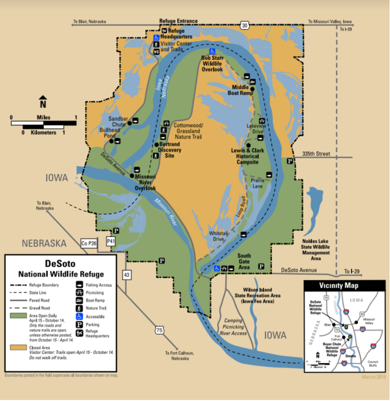
DeSoto National Wildlife Refuge is located along the Missouri River and borders both Iowa and Nebraska. Within its 8,365 acres lies DeSoto Lake, an oxbow lake that used to be a bend in the Missouri River. The refuge contains bottomland forests, tallgrass prairie, and wetland habitats that are managed to mimic the natural Missouri River floodplain habitat to benefit a diversity of migratory birds that flock to the refuge each year in the spring and fall. The refuge also contains a piece of history within its borders, the Bertrand Steamboat. The Bertrand sunk on the bend of river that is now DeSoto Lake, leaving behind the cargo and historic time pieces amounting to almost 250,000 different artifacts housed within the walls of the DeSoto National Wildlife Refuge Visitor Center. DeSoto National Wildlife Refuge is truly a place where wildlife meets history! The refuge provides hiking opportunities through a diversity of refuge habitat. The Bertrand Excavation Site Trail and the Cottonwood and Grassland Nature Trails are open year round on the Nebraska side of DeSoto Lake. The Green Heron Trail and the Missouri Meander Trail are seasonal trails open April 15 - October 14. For detailed information about each trail, check the refuge's trails website. text source: U.S. Fish & Wildlife Service 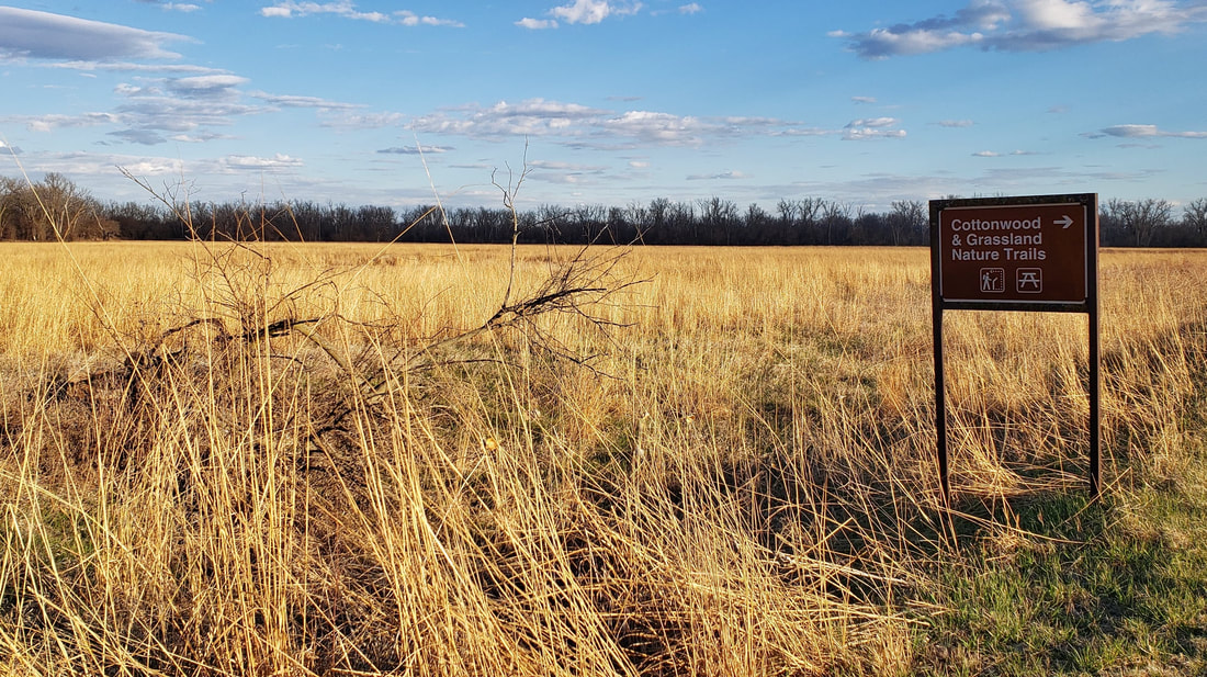 DeSoto National Wildlife Refuge (source: Golden Hills RC&D)
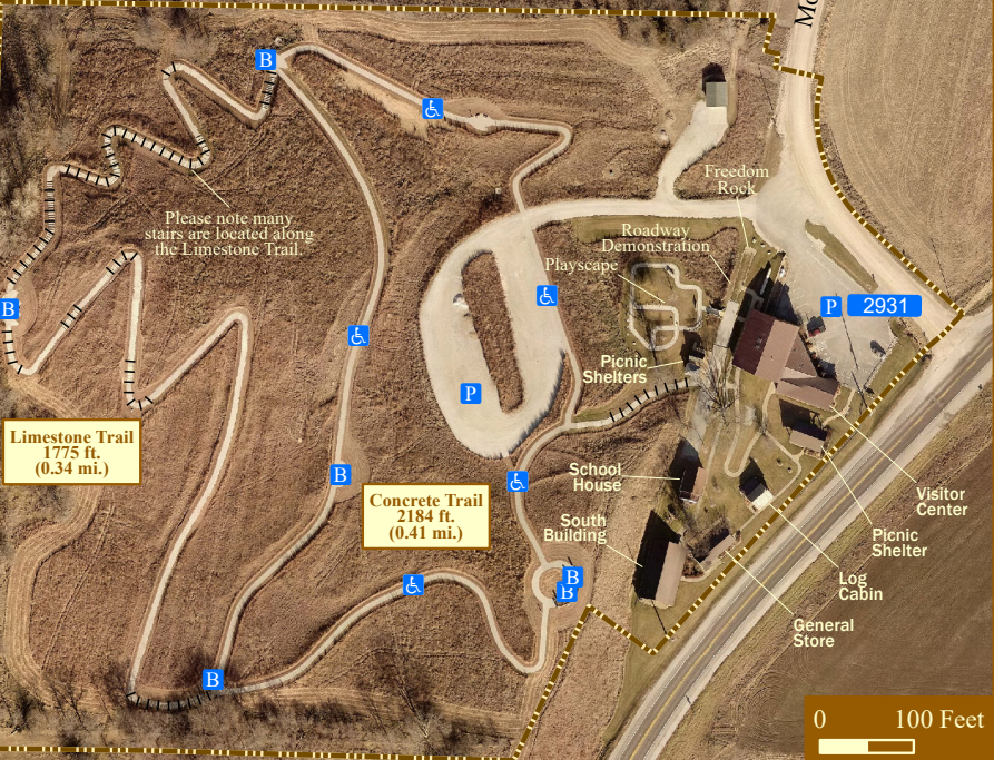
The Harrison County Historical Village and Iowa Welcome Center is located 3 miles northeast of Missouri Valley on Highway 30 (five miles east of Interstate 29, Exit 75). This museum complex is straight out of the 1800s, with an original log cabin, general store, and school. The official Iowa Welcome Center provides tourism information and assistance to travelers. The Iowa Products Store offers food, beverage, clothing, crafts, and a wide variety of souvenirs. Stretch your legs on the 1-mile trail and learn about the Loess Hills. The 0.41-mile Concrete Trail is accessible to wheelchairs. There are many stairs along the 0.34-mile Limestone Trail.  Harrison County Historical Village & Iowa Welcome Center (source: Golden Hills RC&D)
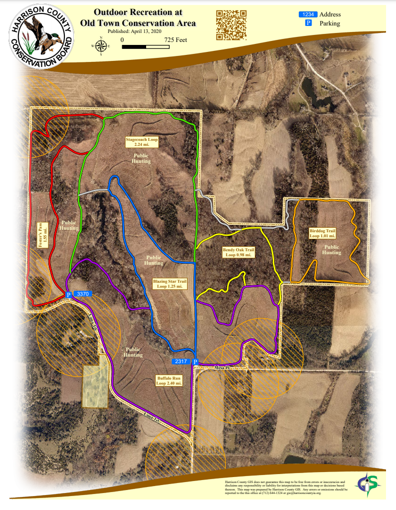
The Old Town Conservation Area is located off Lima Trail about 3 miles southeast of the Loess Hills National Scenic Byway and Missouri Valley. There are two parking areas that provide access to the trails.  Old Town Conservation Area (source: Lance Brisbois)
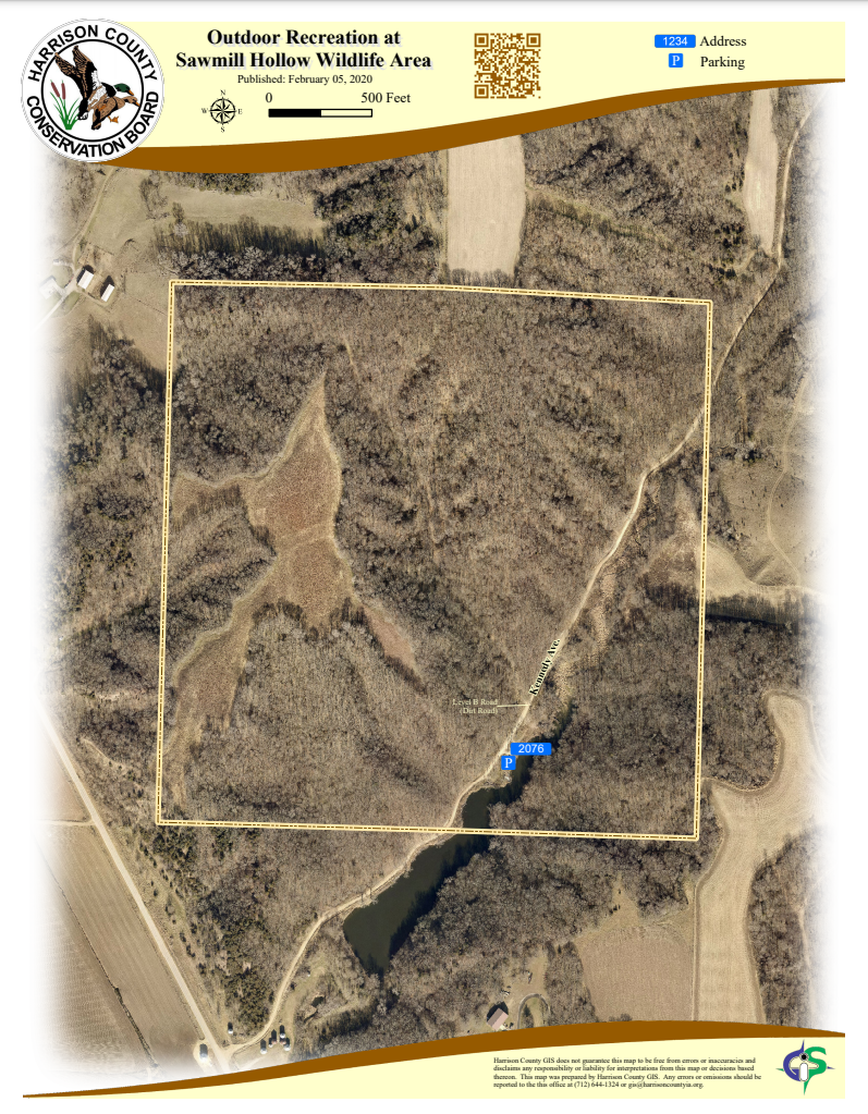
Located seven miles north of Missouri Valley off Loess Hills Trail (L20), the wildlife area is not directly on the byway but is a short drive from the main route. Access to Sawmill Hollow Wildlife Area is on a Level B dirt road. 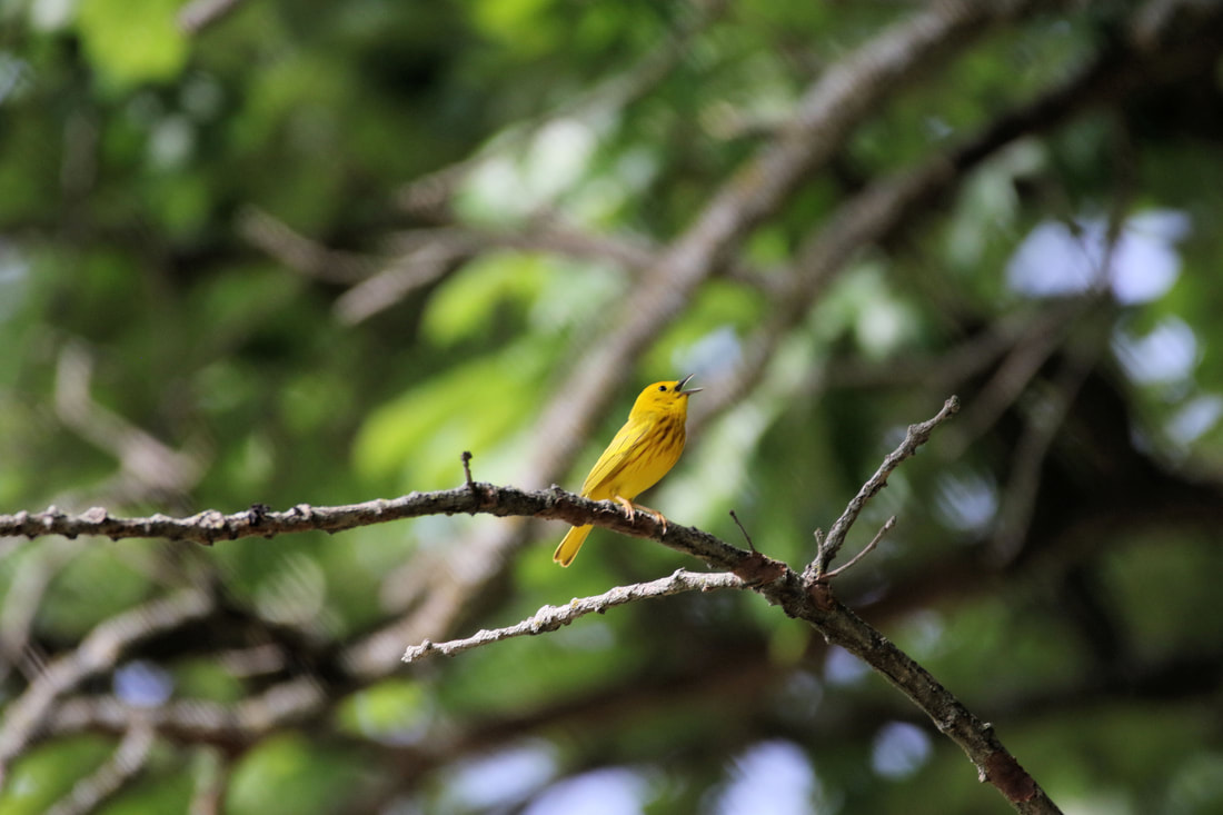 Yellow warbler at Sawmill Hollow Wildlife Area (source: Carter Oliver)
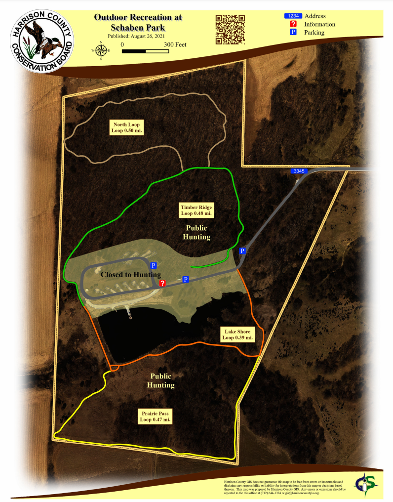
Schaben Park is not located on the Loess Hills National Scenic Byway but is a short drive from the main route or the Orchard Ridge loop. It is located 2 miles off Highway 30, between Woodbine and Dunlap on 141st Lane (gravel road). 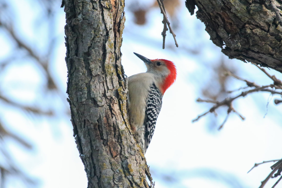 Red-bellied woodpecker at Schaben Park (source: Carter Oliver)
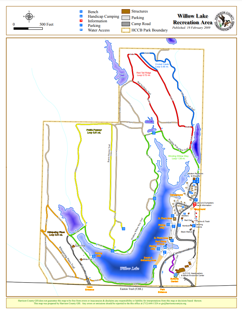
There are 6 miles of hiking trails with Smart Trail interpretive signs using QR (quick response) codes allow users to learn about the Loess Hills and Iowa's natural resources. The Willow Lake Recreation Area is also an excellent location for bird watching, especially migrating songbirds and waterfowl. Willow Lake Recreation Area is not located on the Loess Hills National Scenic Byway but is a short drive from the main route near Logan or the Orchard Ridge loop from Pisgah. It is located 6 miles northwest of Woodbine on F20L (Easton Trail).  Willow Lake Recreation Area (source: Golden Hills RC&D) Hiking the Byways is a regular series by Golden Hills RC&D that features publicly accessible lands open to hiking on the three scenic byways in western Iowa that Golden Hills RC&D coordinates: Glacial Trail Scenic Byway, Loess Hills National Scenic Byway, and Western Skies Scenic Byway. Each Friday a blog post covers hiking areas in one county on one of the aforementioned byways. For questions about hiking on the byways, contact Seth Brooks (seth.brooks@goldenhillsrcd.org).
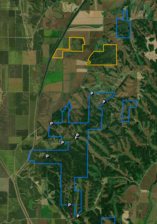
The 964 acre Five Ridge Prairie, a dedicated state preserve in western Plymouth County, exemplifies the northern loess bluffs of western Iowa with a mixture of oak timbered valleys, native prairie ridge tops and west facing slopes. This unique loess landform site is home to several state threatened and endangered plant and animal species. It was also the site of the original wild turkey restoration stocking for Plymouth County. The public is invited to hike and enjoy Five Ridge year round. This is a very large, hilly park, so be sure you let someone know where you will be and when you will be back. Take a map along, and do not cross any fences. Crossing a fence will take you out of our park boundaries and will make it much harder to rescue a lost hiker. Mowed fire breaks offer a number of paths for hikers, snowshoers and cross country skiers alike. Fire breaks are typically mowed in July. Metal sign posts with the exit to the parking lot are clearly marked throughout the fire break system. Public hunting is permitted beginning the 3rd Saturday in September through January 31 according to Iowa DNR regular seasons and hours. Spring wild turkey hunting is permitted all day, each day per Iowa DNR seasons and regulations. It is unlawful to hunt badger, woodchuck, or fox at Five Ridge. No target shooting. text source: Plymouth County Conservation Commonly seen birds: Grasshopper Sparrow, Eastern Kingbird, Rose-breasted Grosbeak Birds to look for: Townsend’s Solitaire, Bobolink, Blue Grosbeak Other Inhabitants: White-tailed Deer, Red Fox, Coyote, Badger wildlife source: Loess Hills Audubon Society
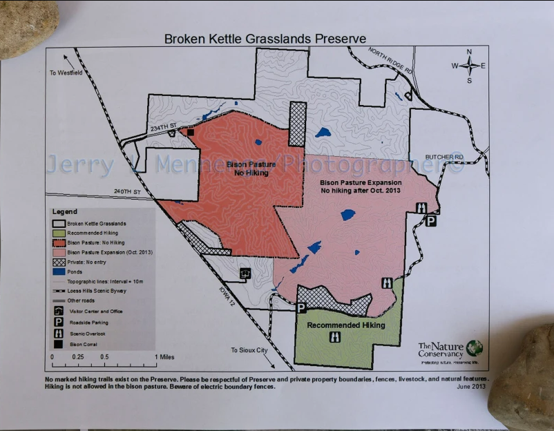
Broken Kettle is a sweeping reminder of nature’s beauty. Not only is it the Nature Conservancy’s largest preserve in Iowa, but it contains the largest remaining prairie in Iowa. In 1999, the Conservancy found the prairie rattlesnake, an extremely rare species, at this site, making Broken Kettle even more important to the region. The Nature Conservancy welcomed a herd of 28 bison at Broken Kettle Grasslands preserve in the fall of 2008—an historic event benefiting the native prairie and the bison herd itself. The extensive prairie ridgetops feature a variety of plants and animals typically found further west in the Great Plains, and also provide a critical habitat for many species of prairie butterflies. This area also hosts the largest tract of contiguous native prairie left in the state. The terrain is steep and rugged in places and predominantly grasslands. Expect to see snakes, insects, grassland birds and breathtaking vistas while you hike. There are no official trails but hiking is permitted south of Butcher Road. text source: The Nature Conservancy Commonly seen birds: Field Sparrow, Bell’s Vireo, Dickcissel, Eastern Meadowlark, Western Meadowlark Birds to look for: Black-billed Magpie, Grasshopper Sparrow, Bobolink, Upland Sandpiper Other Inhabitants: White-tailed Deer; Bison; Coyote; Badger; Great Plains Toad; Plains Spadefoot; Dusted Skipper; Regal Fritillary; Ottoe Skipper; Pawnee Skipper. wildlife source: Loess Hills Audubon Society 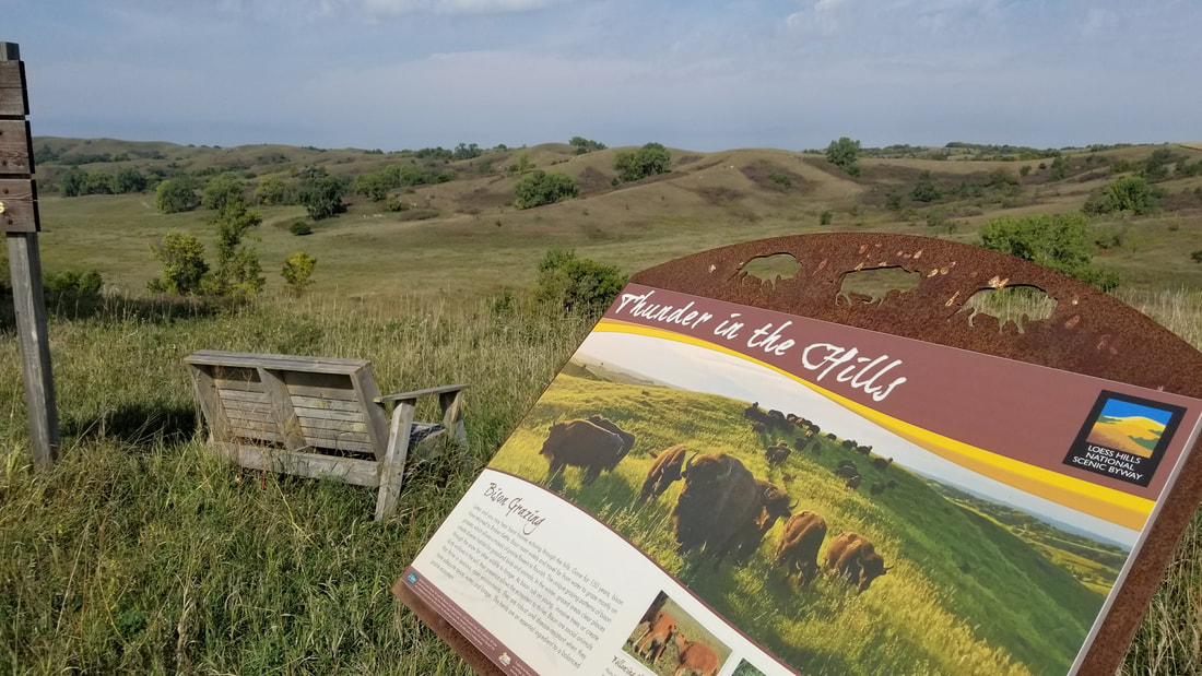 Broken Kettle Grasslands (source: Lance Brisbois)
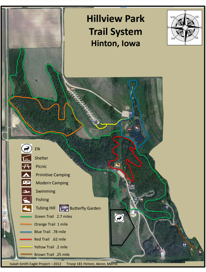
The 580-acre Hillview Recreation Area contains a mixture of open grasslands, reconstructed prairie, oak woodlands, and wildlife habitat. The park also manages a herd of elk. Hillview has a series of trails that can be a short loop or can be combined to take a long walk through the park. Trails wind through oak forests, prairies, and around the pond. The trails are great places to observe the abundant wildlife in the park. There is also a mountain bike trail in the park. During the fall and winter, October 15 - January 10, parts of Hillview are open to public hunting. Should you choose to use the trail system during hunting seasons, please make yourself visible by wearing blaze orange and be aware of your surroundings. text source: Plymouth County Conservation 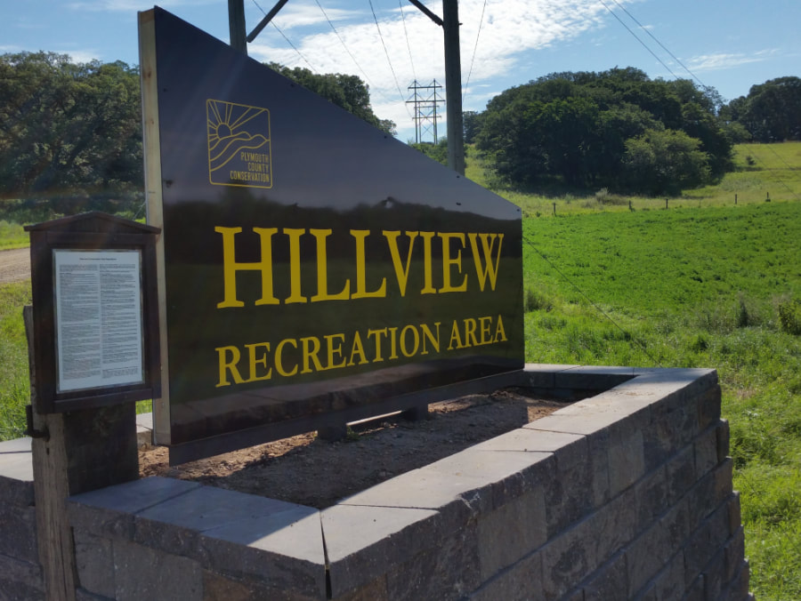 Hillview Recreation Area (source: Travel Iowa)
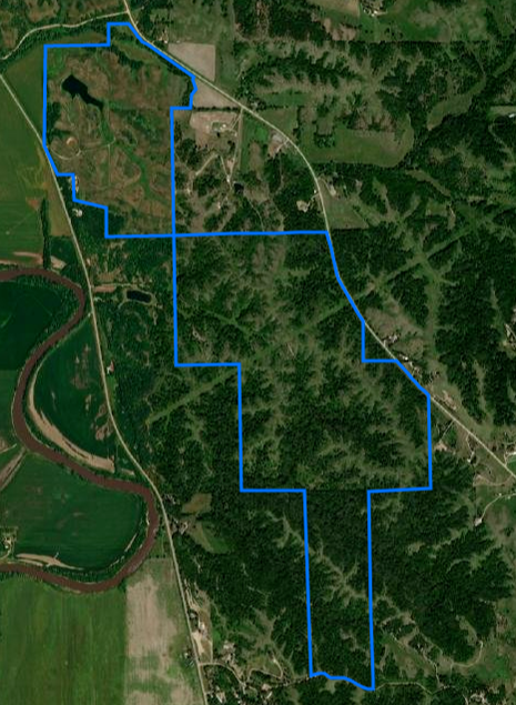
Originally named “Spirit Knoll” (a term coined by the previous owner of the property during the development of a proposed subdivision), the name Heendah Hills was approved by the State Preserves Advisory Board and pays homage to the American Indian identity of the preserve. Heendah is the phonetic pronunciation of “hinda”, meaning Great Horned Owl, in the Ioway/Baxoje language. The Great Horned Owl is a resident species of the region. High quality native prairie is present on approximately 23 acres on a ridge along the south edge of the preserve. An additional 26 acres of formerly grazed prairie with good representation of native plants (“prairie pasture”) is found in the northeast corner of the new preserve. Woodland (with bur oak and other tree species) and thickets form patches scattered on the landscape. Small patches of former cropland now dominated by a variety of volunteer plant species are found below the dam holding a 6-acre pond and in an old bottomland field in the far northeast corner of the preserve. text source: Loess Hills Audubon Society Commonly seen birds: Field Sparrow, Ring-necked pheasant, Dickcissel, Great Horned Owl Birds to look for: Grasshopper Sparrow, Bell’s Vireo, Great Crested Flycatcher Other Inhabitants: White-tailed Deer, Beaver, Badger, Coyote, Ball-nosed Hopper (insect) and Rainbow Grasshopper (first Iowa report of this species) wildlife source: Loess Hills Audubon Society  Heendah Hills State Preserve (source: Lance Brisbois, Golden Hills RC&D)
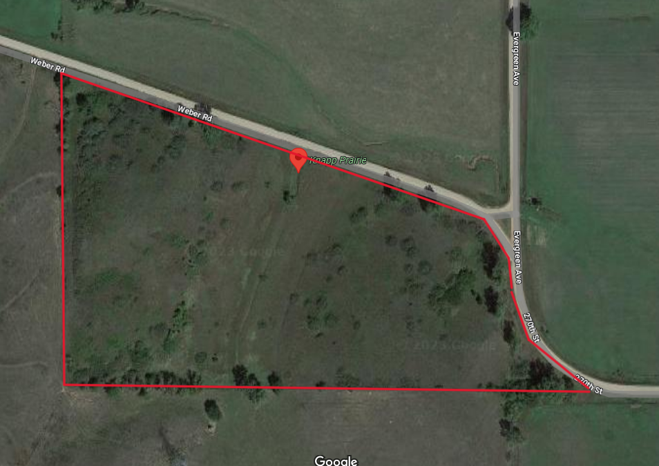
Knapp Prairie was donated to the Nature Conservancy by Barry and Carolyn Knapp in 1997. It is a rare example of mesic Loess Hills prairie growing on the lower portions of moderate slopes, saved from conversion to row crops or brome pasture by the tradition of cutting prairie hay. This site is an important seed source for the reconstruction of lower slopes and valleys at other nearby preserves. Knapp Prairie Preserve is dominated by tallgrass prairie species adapted to deeper, mesic loess soils. Knapp Prairie is also an important prairie butterfly conservation area. More than 900 regal fritillaries, orange and yellow butterflies, have been observed in a single survey at Knapp prairie, making it one of the largest U.S. populations of this butterfly. The Conservancy harvests seeds from the plants that attract these butterflies for use in restoring other prairies in the area. The terrain is steep and rugged in places and predominantly grasslands. Expect to see snakes, insects, grassland birds and breathtaking vistas while you hike. There are not any official trails but hiking is permitted throughout. text source: The Nature Conservancy
Hiking the Byways is a regular series by Golden Hills RC&D that features publicly accessible lands open to hiking on the three scenic byways in western Iowa that Golden Hills RC&D coordinates: Glacial Trail Scenic Byway, Loess Hills National Scenic Byway, and Western Skies Scenic Byway. Each Friday a blog post covers hiking areas in one county on one of the aforementioned byways. For questions about hiking on the byways, contact Seth Brooks (seth.brooks@goldenhillsrcd.org).
|
Archives
April 2024
Categories
All
|


 RSS Feed