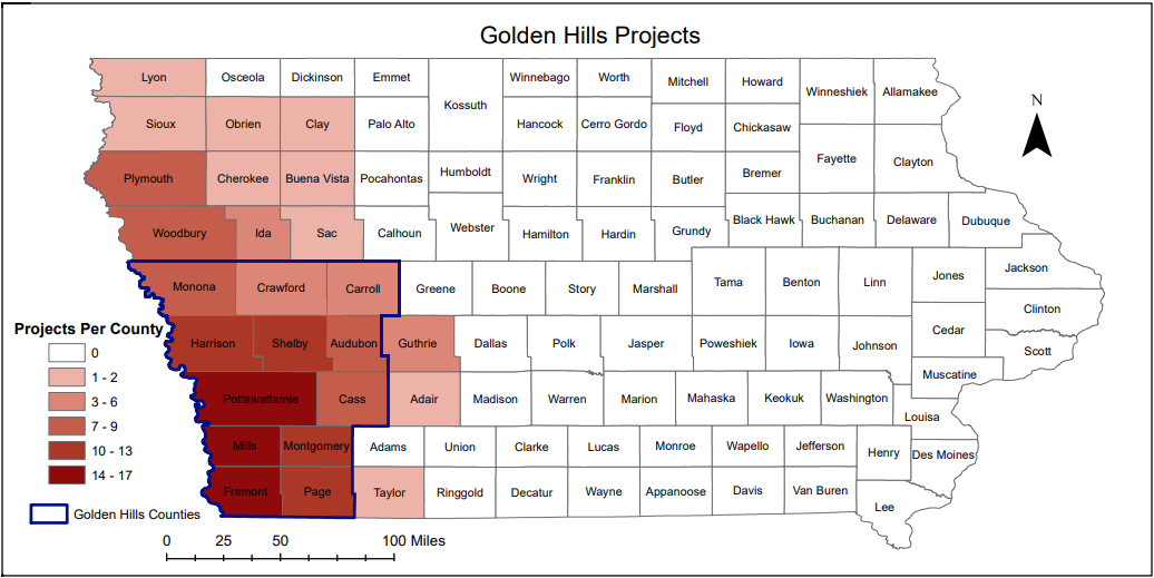
Golden Hills works throughout western Iowa. Our "official" territory from our original organizational bylaws is an 8-county region in the southwestern portion of the state: Cass, Fremont, Harrison, Mills, Montgomery, Page, Pottawattamie, and Shelby. In 2023, we added four more: Audubon, Carroll, Crawford, and Monona. Several projects extend event beyond these 12 counties into more than 20 counties (see map below). The Loess Hills National Scenic Byway, Western Skies Scenic Byway, Glacial Trail Scenic Byway, Hungry Canyons Alliance, and the East & West Nishnabotna Watershed Coalitions are some projects that extend outside of our "official" region.
The area includes the ancestral lands of the Báxoje Máyaⁿ (Ioway), Očhéthi Šakówiŋ; Umoⁿhoⁿ tóⁿde ukʰéthiⁿ (Omaha), Washtáge Moⁿzháⁿ (Kaw/Kansa), and Yankton peoples.
Our work is primarily focused within three distinct Iowa landforms. The Missouri Alluvial Plain along the state border with Nebraska to the west is the wide, flat floodplain of the Mighty Missouri. The Loess Hills are steep bluffs of glacial till that run parallel to the Missouri River Valley. The Southern Iowa Drift Plain consists of rolling hills just to the east of the Loess Hills.
The region is largely rural and agricultural, with the exception of the metropolitan cities of Council Bluffs and Sioux City. Several communities have more than 5,000 residents, but most communities have fewer than 2,000 residents.
Many state, county, and city parks and trails are located throughout the region, offering a plethora of outdoor recreation opportunities. Hunting, fishing, foraging, hiking, biking, paddling, and horseback riding are just a few of the activities enjoyed on our public lands and waters.
Wondering if Golden Hills might be able to assist with your community or project? Please feel free to contact us and ask!
Address712 South Highway Street
P.O. Box 189 Oakland, IA 51560 |
ContactPhone: 712-482-3029
General inquiries: [email protected] Visit our Staff Page for email addresses and office hours. |

