GOLDEN HILLS RC&D
  • Home
  • About Us
    • Job Openings
    • Who We Are
    • What We Do >
      • Community Partnerships
      • Arts and Culture
      • Water Resources
      • Local Foods
      • Outdoor Recreation & Tourism
      • Land Stewardship
  • Where We Work
  • Events
  • News
  • Donate to Golden Hills

News

Hiking the Loess Hills National Scenic Byway: Woodbury County

3/24/2023

0 Comments

 
Picture
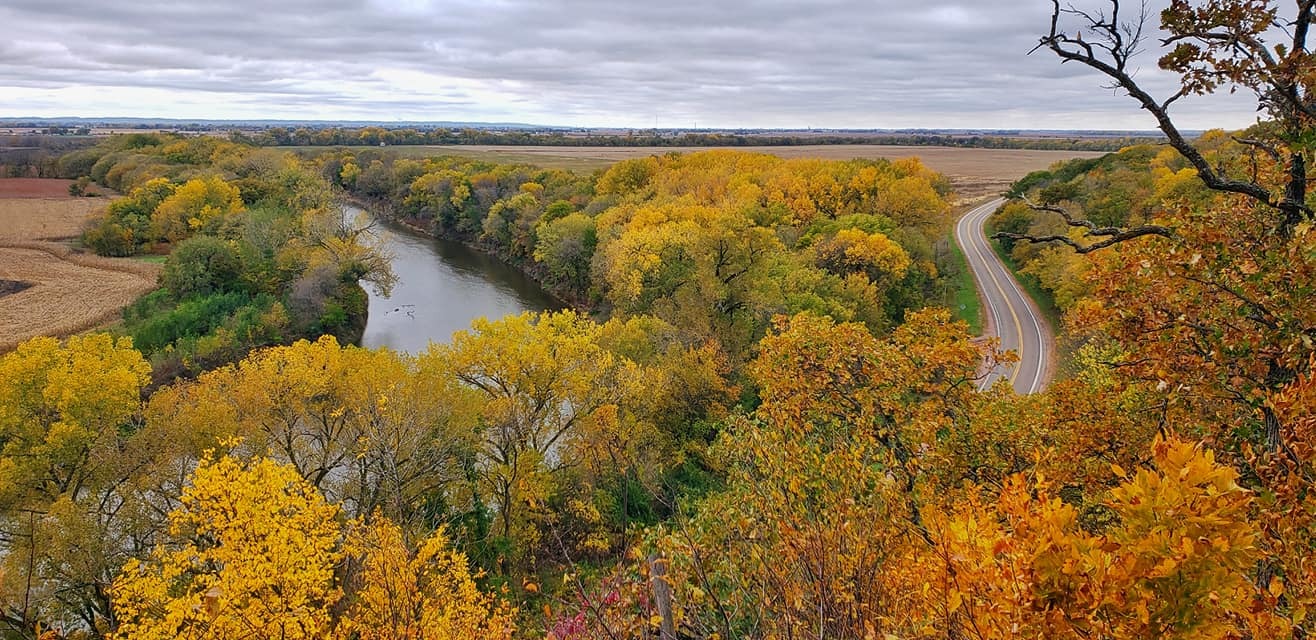
Stone State Park (photo by Lance Brisbois)
This week's edition of Hiking the Byways takes us to Woodbury County on the Loess Hills National Scenic Byway.

Stone State Park is the jewel of hiking in the county, however, there are plenty of diamonds in the rough. Sioux City Prairie is one of the nation's largest urban prairies. In the southern part of the county, Southwood Conservation Area and the adjacent Fowler Forest Preserve offer an escape away from the city, while Oak Ridge Conservation Area welcomes adventurous hikers a truly off-the-beaten-path experience with no official maintained trails but over 2,000 acres of wilderness to explore off-trail.
Picture

Stone State Park

​Manager: Iowa DNR
Location: ​
5001 Talbot Rd, Sioux City
Acres: 1,069
Trails: 15-mile trail system​
Camping: Yes (modern, tent, cabins)
Amenities: Shelters, restrooms​
Dogs: Yes, on leash
Hunting: No

​
Stone State Park, is an urban wildlife sanctuary on the edge of Sioux City and the heart of the Loess Hills. Visitors can explore the natural history of the park by walking its 15 miles of trails looking for wildlife and birds.
Picture
Click to download the PDF map
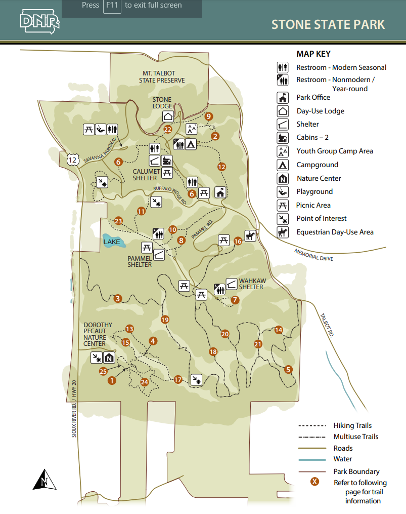
The Carolyn Benne Nature Trail details the natural history of the area on an interpretive walk through the park and features one of the best scenic views in the park. The popular  Tunnel Trail gets its name from a tunnel that runs underneath the park road. Buffalo Run Trail leads to Dakota Point Overlook, aptly named with views of South Dakota to the west. Another viewpoint, Elk Point, has excellent views of the southern half of the park.

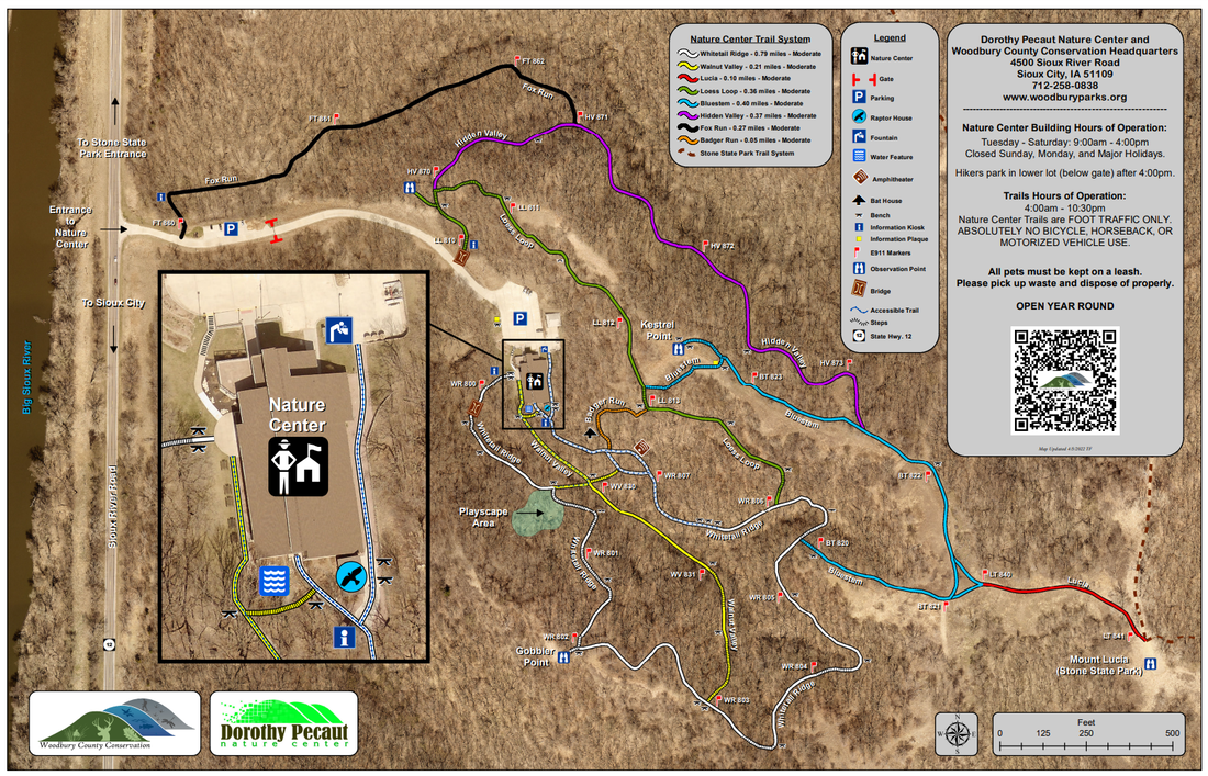
The trails in the southern half are more rugged and wild as they do not cross park roads or enter campgrounds. Perhaps the best trail in the park, Mt. Lucia, leads to a viewpoint at the southern end of Stone State Park. You can connect with trails leading to Dorothy Pecaut Nature Center at the overlook. The trails in the southern half are your best bet for a slice of woodland wander that is easily accessible due to its proximity to Sioux City and Interstate 29.

Dorothy Pecaut Nature Center

​Manager: Woodbury Conservation
Location: 4500 Sioux River Rd, Sioux City
Trails: 2.5-mile trail system
Camping: No
Amenities: Water fountain, restrooms
Dog-friendly: Yes, on leash
Hunting: No
Picture
Click to download the PDF map
Hike a trail and let prairie grasses tickle your chin. Explore bur oak forests with 150-year old giants. Climb the ridges and imagine what Lewis and Clark might have seen. The 2.5 miles of trails explore prairie ridges and woodlands. A section of Whitetail Ridge Trail is accessible for people with mobility difficulties. Hikers park in lower lot (below gate) after 4:00pm. Trails are open year-round from 4:30 AM to 10:00 PM.

Sioux City Prairie
​
​Manager
: The Nature Conservancy
Location: 42.521302, -96.438305
Trails: 2 miles of trails (no map available)
Camping: No
Amenities: None
Dogs: Not allowed
Hunting: No​
Picture
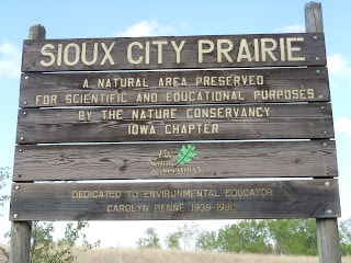
Sioux City Prairie is one of the nation’s largest native prairie tracts found in an urban setting. An area uniquely and delicately balanced between the city and the wild, it allows visitors an escape from city life by immersing themselves in a tallgrass prairie.

Sioux City Prairie is a TNC-owned 150-acre tallgrass prairie preserve. The prairie and wooded valleys of this well-drained, high-relief landscape support a variety of plants and animals typically found further west in the Great Plains. The preserve also supports a diverse population of birds and it provides critical habitat for many species of prairie butterflies.

Bacon Creek Park

​Manager: Sioux City Parks & Recreation
GPS: 42.494696, -96.338502
Trails: 3 miles (no map available)
Camping: No
Amenities: Picnic area, shelters, restrooms
Dogs: Yes, on leash
Hunting: No​
Picture
Picture

Cone Park & Sertoma Park

​Manager: Sioux City Parks & Recreation
GPS: 42.442543, -96.362727
Trails: 2-mile loop
Camping: No
Amenities: Restrooms
Dogs: Yes, on leash
Hunting: No​
Picture
Enjoy a 2-mile trail loop that extends through Cone Park and Sertoma Park. For more trails in Sioux City visit the Parks and Recreation Trail Page, or call Parks and Recreation at (712) 279-6126. Off shoot trails offer non-paved hiking trails.
Picture

Southwood Conservation Area

​Manager: Woodbury Conservation
GPS: 42.228946, -95.947836
Acres: 623
Trails
: 3 miles
Camping: Yes
Amenities: Restrooms
Dogs: Yes, on leash
Hunting: Yes, during season

​Located one mile southwest of Smithland, this area highlights Loess Hills open grassland and timbered areas. 
Picture
Click to download the PDF map
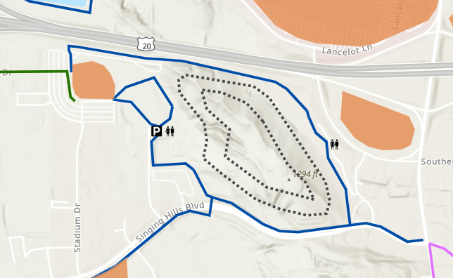
Trails of the area take the visitor through a variety of habitats. A self-guided nature trail brochure is available at the trail head. Numerous bluebird boxes have been erected in the area and visitors may catch a glimpse of the brilliant blue birds.

Park facilities are open May 1 through October 31.
Picture

Fowler Forest Preserve

​Manager: Woodbury Conservation
GPS: 42.232340, -95.945248
Acres: 160
Trails
: 1 mile
Camping: No
Amenities: Picnic shelter, restrooms
Dogs: Yes, on leash
Hunting: Not on the wildlife refuge where the trail is located
Picture
Click to download the PDF map
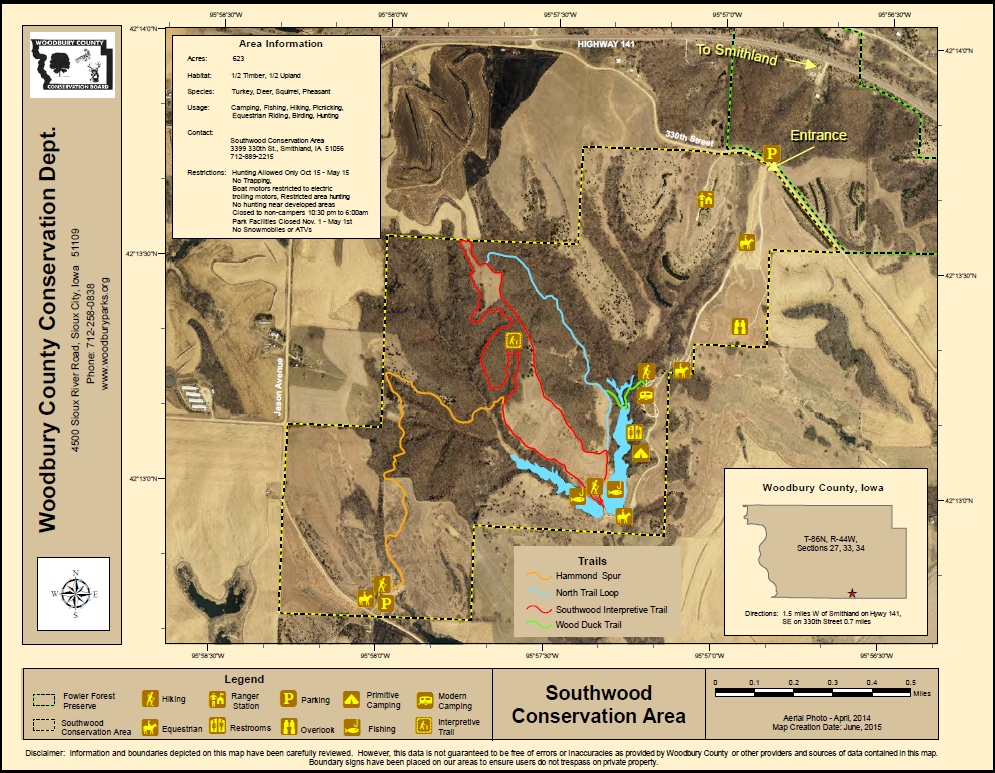
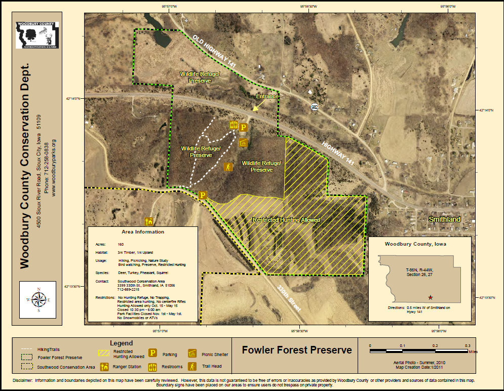
Located one-half mile west of Smithland on Hwy 141 near the Southwood Conservation Area, this 160 acre area is a perfect spot for a picnic or a walk through the woods. Park facilities are open and pressurized water systems are available May 1 through October 31.
Picture

Oak Ridge Conservation Area

​Manager: Woodbury Conservation
Location: Deer Run Trail, Oto, IA 51044
​Acres: 2,082
Trails: No official trails but hiking allowed
Camping: No
Amenities: None
Dogs: Yes, on leash
Hunting: Yes​
Picture
Click to download the PDF map
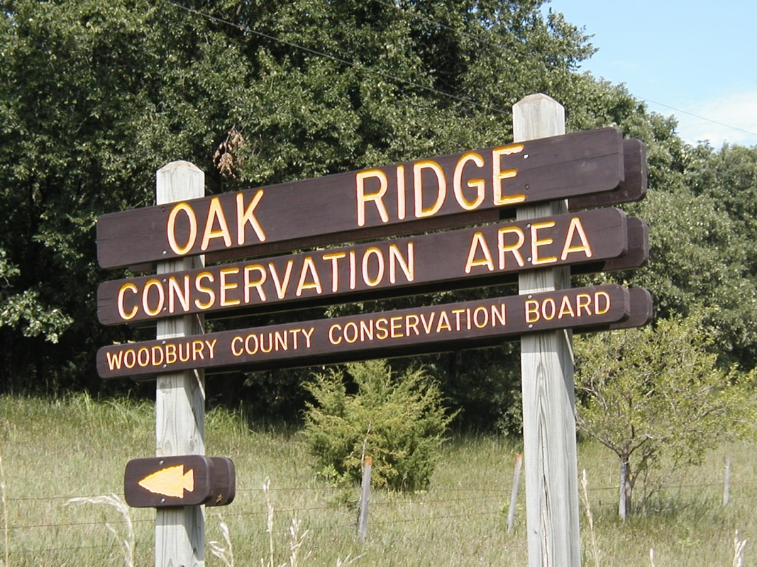
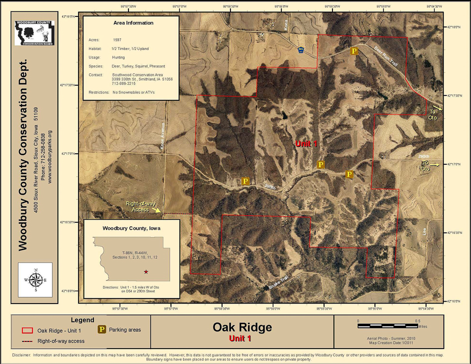
Encompassing more than 2,082 acres of public land in the hills adjacent to the Little Sioux River Valley, Oak Ridge is divided into four units with six public parking accesses between Oto and Smithland. This natural, undeveloped area is available for hiking and public hunting.
Picture

Curtin Timber

​Manager: Woodbury Conservation​
Location: 42.313114, -95.869766
Acres: 210
​Trails
: No official trails but hiking allowed 
Camping: No
Amenities: None
Dogs: Yes, on leash
Hunting: Yes​
Picture
Click to download the PDF map
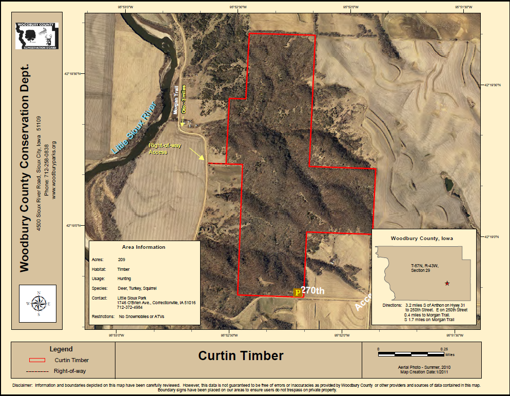
This 210-acre area is located four miles southeast of Anthon. It is an undeveloped public wildlife area for hiking and hunting. Wildlife and wildflowers are abundant.

Shagbark Hills

​Manager: Woodbury Conservation
Location: 42.455177, -95.786987
​
Acres: 379
Trails: No official trails but hiking allowed
Camping: No
Amenities: None
Dogs: Yes, on leash
Hunting: Yes
Picture
Click to download the PDF map
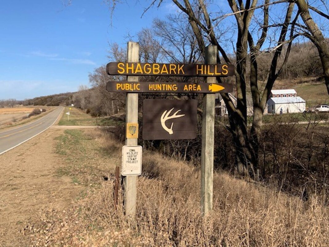
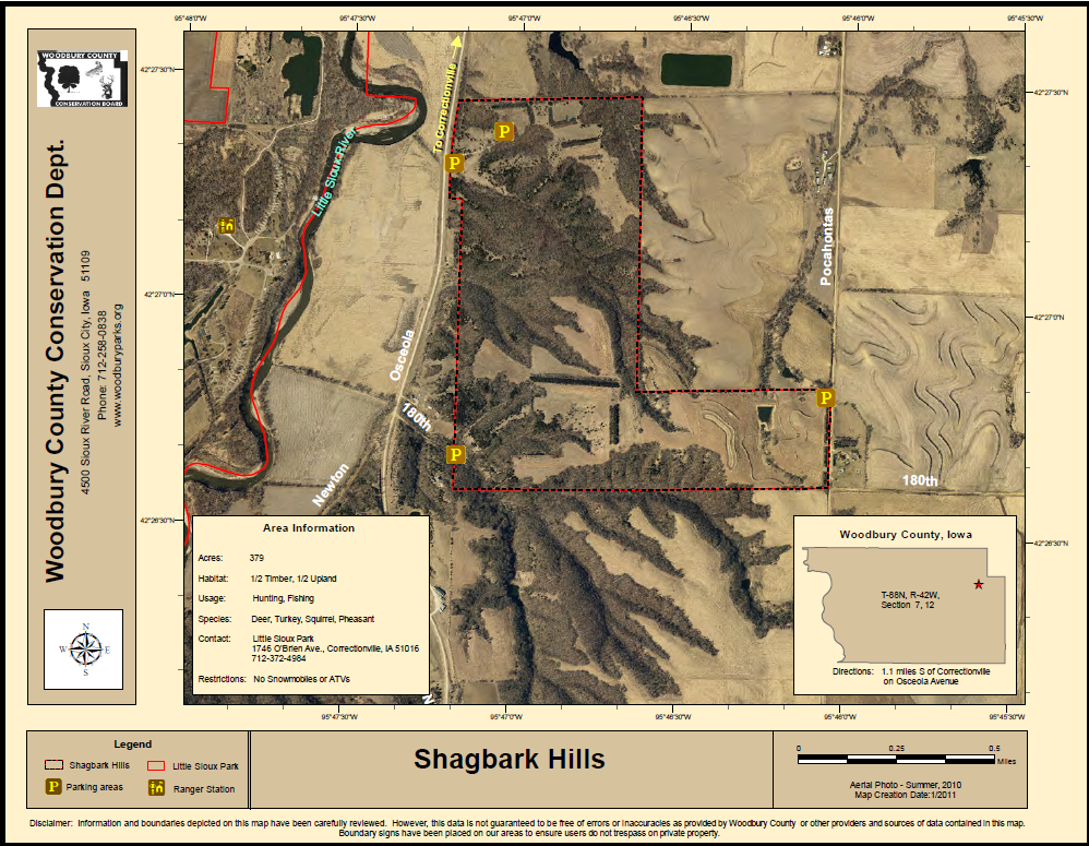
Shagbark Hills was acquired in 1976 for wildlife habitat. The area contains a native stand of shagbark hickory trees unique to the area. The undeveloped 379-acre area is located one-half mile south of Correctionville and is open for hiking and public hunting.
Picture

Hiking the Byways is a regular series by Golden Hills RC&D that features publicly accessible lands open to hiking on the three scenic byways in western Iowa that Golden Hills RC&D coordinates: Glacial Trail Scenic Byway, Loess Hills National Scenic Byway, and Western Skies Scenic Byway. Each Friday a blog post covers hiking areas in one county on one of the aforementioned byways. For questions about hiking on the byways, contact Seth Brooks (seth.brooks@goldenhillsrcd.org).
0 Comments


Leave a Reply.

    Archives

    May 2023
    April 2023
    March 2023
    February 2023
    January 2023
    December 2022
    November 2022
    May 2022
    April 2022
    February 2022
    January 2022
    December 2021
    November 2021
    October 2021
    August 2021
    July 2021
    June 2021
    May 2021
    April 2021
    March 2021
    February 2021
    December 2020
    November 2020
    October 2020
    September 2020
    August 2020
    July 2020
    June 2020
    May 2020
    April 2020
    January 2020
    December 2019
    September 2019
    August 2019
    July 2019
    May 2019
    April 2019
    March 2019
    January 2019
    November 2018
    October 2018
    September 2018
    August 2018
    July 2018
    May 2018
    April 2018

    Categories

    All
    Arts & Culture
    Botany On The Byways
    Community Partnerships
    Hiking The Byways
    Land Stewardship
    Local Foods
    Outdoor Recreation & Tourism
    Water Resources

    RSS Feed

      Newsletter sign-up

    Subscribe to Newsletter

Address

712 South Highway Street 
P.O. Box 189
​Oakland, IA 51560

Contact

Phone: 712-482-3029
General inquiries: info@goldenhillsrcd.org
Visit our Staff Page for email addresses and office hours.
  • Home
  • About Us
    • Job Openings
    • Who We Are
    • What We Do >
      • Community Partnerships
      • Arts and Culture
      • Water Resources
      • Local Foods
      • Outdoor Recreation & Tourism
      • Land Stewardship
  • Where We Work
  • Events
  • News
  • Donate to Golden Hills