|
The Iowa DNR, in collaboration with the Iowa Department of Agriculture and Land Stewardship, the U.S. Geological Survey, and The Iowa Homeland Security and Emergency Management Division, prepares the Water Summary Update. It is a quick view of four ways to explain the status of Iowa’s water resources and observes events affecting water supplies. It is published every two weeks or as conditions significantly change.
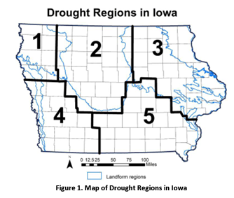
The landform regions have irregular boundaries but the drought regions follow county boundaries for planning and administrative purposes. Regions 1 and 4 lie entirely within western Iowa, while about half of Region 2 overlaps with the western region of the state. Region 1 encompasses eight counties in northwest Iowa in a landform area that corresponds to the Northwest Iowa Plains. The gently rolling landscape consists of wind-blown silt (loess) overlying fine-textured glacial till. The area is drier than elsewhere in Iowa and the intensely agricultural region relies heavily on groundwater obtained from shallow alluvial aquifers or deeper bedrock aquifers for irrigation, livestock watering, and municipal and private water supplies. A reliance on shallow groundwater sources makes the region more vulnerable to water supply shortages during drought. In this region, many private and public water users rely on Rural Water Districts that distribute water from centralized sources. Region 4 consists of 16 counties in southwest Iowa where the thick deposits of silt (loess) form steeply sloping hills and narrow valleys. The loess thins from a thickness of more than 100 feet along the Missouri River margin to tens of feet to the east tier of counties. The loess overlies fine-textured and dense glacial till. Bedrock groundwater resources are very poor in the region and characterized by highly mineralized and poor-yielding Pennsylvanian shales, limestone and sandstone. Deeper bedrock formations also contain poor water quality. Primary aquifers in the region consist of shallow sand and gravel deposits along major rivers and these units are particularly susceptible to overuse and drought. Many private and public water users rely on Rural Water Districts that distribute water from centralized sources collected from lakes, impoundments and developed well fields. Region 2 corresponds to the Des Moines Lobe region of Iowa, a landscape region of recent glaciation (<12,000 years old) consisting of a flat to gently undulating, poorly drained flat till plains marked by numerous small, poorly drained depressions and wetlands. Dominant soils consist of silty and loamy soils formed in glacial till and wetlands. Poor drainage characteristics and high water table levels in the region necessitated the building of widespread artificial drainage systems of subsurface tiles and ditches to improve the land for crop production. Today the land use in the region is dominated by corn and soybean production and the area is among the most productive crop regions in the world. The intense cropping in the region is vulnerable to drought-induced impacts to yields. Bedrock aquifers are available in the region for water supply and additional groundwater resources are available from alluvial sand and gravel aquifers.
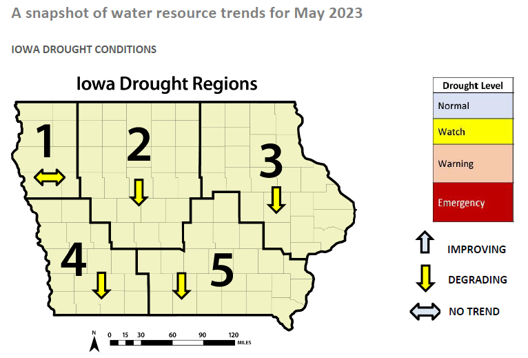
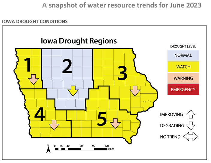
Upon a superficial look, drought conditions improved in June as compared to May. The drought level in Region 2 was upgraded to normal, while the rest of the state's regions remained on drought watch. Water resource trends in Region 4 continued to degrade in June, however, Region 1's trend shifted negatively last month after showing no trend in May. Perhaps increased precipitation in July will stabilize or reverse the downward trends in all drought regions in western Iowa. 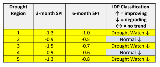 Standardized Precipitation Index (SPI) The SPI is an index based on accumulated precipitation for various time scales. SPI is the most commonly used indicator worldwide for detecting and characterizing meteorological droughts. The SPI indicator measures precipitation differences based on a comparison of observed total precipitation amounts over the period of interest with the long-term historical precipitation record for that period. Droughts are characterized by negative SPI values, while positive SPI values indicate wet periods. The range of SPI values is between -2 and +2. Looking at the SPI table for June, drought conditions have increased across the state over the last three months. Region 1 in northwest Iowa is under a drought watch according to the SPI, while Regions 2 and 4 are classified as normal; both regions 3-month SPI is below -1.0. 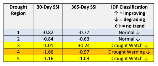 Standardized Streamflow Index (SSI) and Streamflow SSI is a metric that compares current streamflow against the historical record to determine how far away the current streamflow value is from the river’s historical mean observed on the same date. For this WSU daily streamflow yields from approximately six to 12 rivers in each region are averaged to create the region’s mean daily flow, which is then compared to historical streamflow since 1960 to determine how current streamflow fits into historical context. Drought index values typically range from 0 (streamflow is the same as the mean) to -3, which indicates the current streamflow is three standard deviations less than the historical mean for the period. Positive SSI values indicate wetter than normal or flood-level flows. If you have driven over the West Nishnabotna River or any of its tributaries in June, you probably noticed the low water level and streamflow. Unfortunately, a paddle on the West Nishnabotna Water Trail is impractical with current water conditions. The SSI lists Region 4 in a drought warning with significantly lower streamflow compared to historical records. 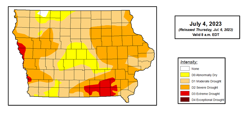 July 2023 Seasonal Outlook During the month of June, Severe Drought (D2) increased in significant portions of western Iowa counties. The area of Severe Drought (D2) now covers western and eastern Iowa, with about 40 percent of the state classified as D2. Additionally, the southwestern corner of Pottawattamie County and the northwestern corner of Mills County are now classified as Extreme Drought (D3). Less than one percent of Iowa is now free from drought or abnormal dryness. Abnormal dryness or drought conditions have now been continuously present in Iowa for more than three years. The last USDM to show no dryness or drought in the state was May 5, 2020. This is the longest continuous period of dryness or drought in Iowa since the start of the USDM in 2000. 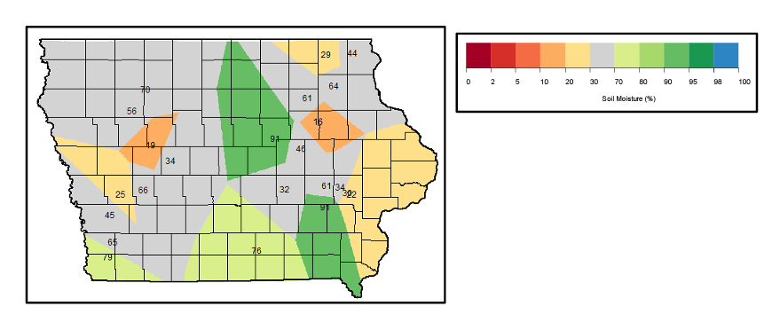 Soil moisture trends in western Iowa during the month of June were a mixed bag. The southwestern corner of Iowa, including all of Fremont County, most of Page county, and half of Mills County, saw increased soil moisture from May to June. However, portions of Woodbury, Monona, Harrison, Shelby, Pottawattamie, Cass, Crawford, Carroll, Ida, and Sac counties experienced decreases in soil moisture in June.
0 Comments
Leave a Reply. |
Archives
June 2024
Categories
All
|
 RSS Feed