GOLDEN HILLS RC&D
  • Home
  • About Us
    • Job Openings
    • Who We Are
    • Where We Work
    • What We Do >
      • Community Partnerships
      • Arts and Culture
      • Water Resources
      • Local Foods
      • Outdoor Recreation & Tourism
      • Land Stewardship
  • News
  • Events
  • Donate to Golden Hills

News

How to Hike Brent's Trail in Iowa's Loess Hills

5/22/2024

0 Comments

 
Picture
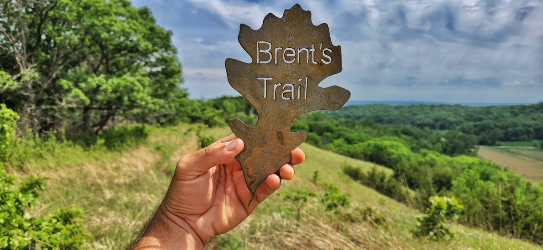
Photo by Lance Brisbois
Brent's Trail is dedicated in loving memory to Brent Olson, the area forester for the Loess Hills State Forest. Brent had a vision of a long-distance hiking trail in Harrison County—​he wanted people to experience the beauty of the Loess Hills in a unique way, and the trail named in his honor delivers in every aspect.

Since its opening in 2019, Brent's Trail has gained national attention as one of the best (and most difficult!) hikes in the state of Iowa. It's a partnership between Harrison County Conservation Board and Iowa Department of Natural Resources. Other partners and supporters include Friends of Loess Hills State Forest and Preparation Canyon State Park, Loess Hills Missouri River Region, Golden Hills RC&D, and Loess Hills Alliance.
​Brent's Trail is an 8-mile hiking trail connecting Harrison County Conservation’s Murray Hill Scenic Overlook and Gleason-Hubel Wildlife Area via the Loess Hills State Forest. The trail is the start of a proposed trail that will eventually connect the northern and southern ends of the State Forest. A three-mile southern extension was added in 2021, giving hikers the choice of an 11-mile arduous trek through the state forest. Primitive, dispersed camping is allowed within Loess Hills State Forest. Potable water and restrooms are not available along the trail.

Where should you start Brent's Trail?

Picture
Click to download the trail map
There are three main trailheads for Brent's Trail:
  1. Murray Hill Scenic Overlook
  2. Gleason-Hubel Wildlife Area
  3. 1545 165th Trail

​The original route connected Murray Hill and Gleason-Hubel for an eight-mile point-to-point hike. A three-mile extension was added to the southern end of the Little Sioux Unit of the Loess Hills State Forest, giving hikers the opportunity for an 11-mile trek.

Regardless of whether you start at the northern or southern end, you will have a steep climb near the end of your hike when you are tired.
Unfortunately, there are no shuttle services to return you from one trailhead to another. While not eco-friendly, the simplest solution is to drive two cars and leave one at your finishing point, whether that is one of the three trailheads or another point along Brent's Trail.

Our preferred route is to begin at Murray Hill Scenic Overlook, as the views are better hiking south.

Picture
Photo by Lance Brisbois

What if you only have one car?

Picture
Intersection of the original route and southern extension. Photo by Lance Brisbois.
Brent's Trail is a point-to-point hike, which makes hiking the trail complicated if you only drive one car to a trailhead. Many hikers will hike from one end to the other and return to their starting point by walking Larpenteur Memorial Road. This gravel road at the foot of the Loess Hills has light traffic, but caution should be taken if you hike back to your car on the road.

If road walking is not appealing to you, you have a few options to return to your starting point. An obvious one is to return in the opposite direction on Brent's Trail. You will need extra energy, snacks, and water if you decide on this option. You can cache water and other supplies at one of the parking areas listed on the trail map (blue address signs).
Another option is to turn around at the parking area at 1715 138th Trail and return in the opposite direction. This parking area in the state forest is approximately the halfway point of the original 8-mile Brent's Trail, which makes it an ideal place to turn around whether you begin at Murray Hill or Gleason-Hubel. There is plenty of shade in this parking area, so you can rest before resuming your journey.
Starting at Murray Hill gives hikers several options for routes that return to Murray Hill. If you want a taste of Brent's Trail, hike from Murray Hill to Fountainbleu Cemetery, then head west on 124th Trail until reaching Easton Trail/Larpenteur Memorial Road. Head north alongside the road until you reach the southern end of the Goodman Property (refer to the trail map) and follow Brent's Trail north to climb steeply up Murray Hill. This hike is short at three miles but your heart will be pumping as there are two steep climbs totaling nearly 800 feet of elevation gain!

Hikers can also use the trails in the state forest (see map above) to extend their hike or use them to return to the trailhead where they began their hike.
Picture
A three-mile lollipop route from Murray Hill (click for an AllTrails track)

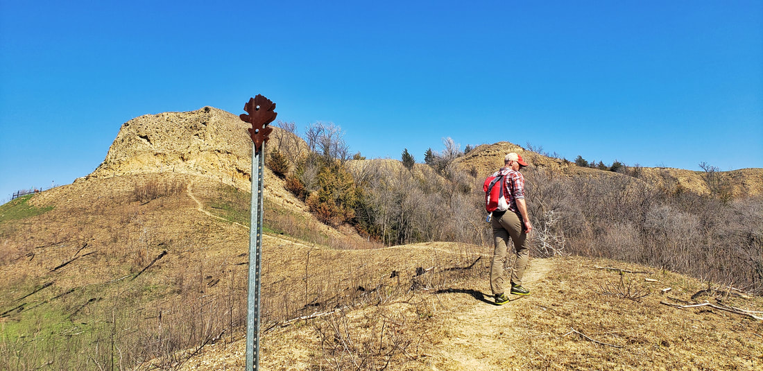
What are the top scenic spots along Brent's Trail?

Picture
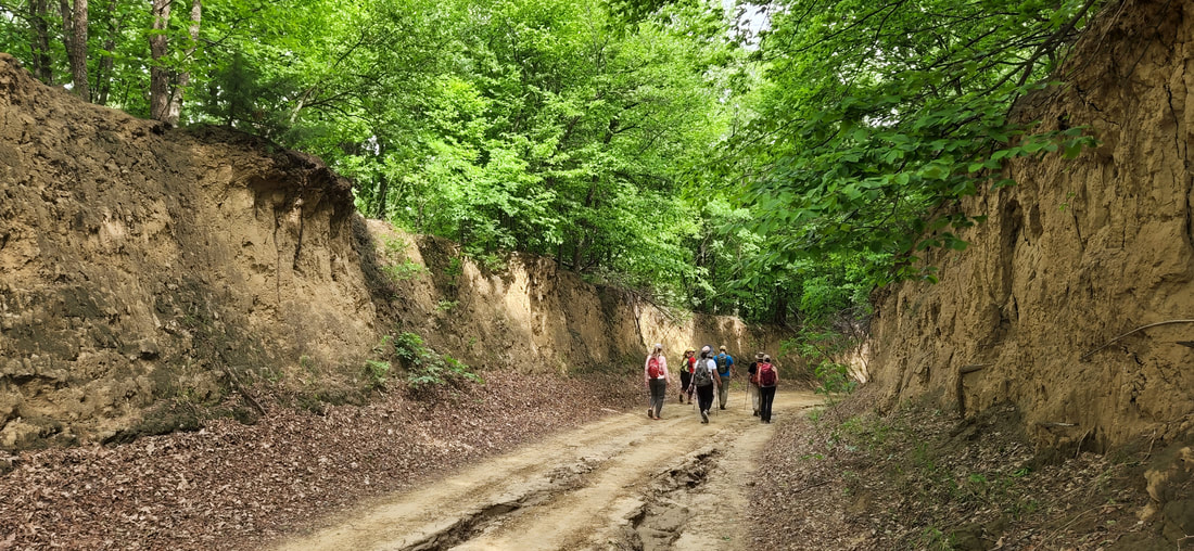
Sections of Brent's Trail follows classic Loess Hills road cuts. Photo by Lance Brisbois.
Murray Hill - Murray Hill Scenic Overlook offers a panoramic view of the Missouri River Valley. Yucca plants and native flowers dominate the Loess Hill prairie landscape. Interpretive signs are located at the overlook that explain the significance and history of the Loess Hills. Make the steep climb on the trail and you will be rewarded with one of the most picturesque locations in the Loess Hills.
Goodman Property - Donated by Jim "Doc" Goodman, this area has four acres and is located just south of Murray Hill Scenic Overlook. It is unique with native prairie remnant and deposits of rocks from glacial till deposited thousands of years ago. 

​Fountainbleu Cemetery - Charles Larpenteur was an early French fur trader who came to this area in the early 1800s. Larpenteur established the town of Fontainbleu and a trading post at the base of Murray Hill. He is buried at this cemetery.

124th Trail - After leaving Fountainbleu Cemetery, Brent's Trail follows 124th Trail. Once a through road but now closed to through traffic, this section is a classic example of a Loess Hills road cut.
Picture
Fountainbleu Cemetery. Photo by Seth Brooks.
View of the Missouri and Little Sioux - Overlooking 138th Trail near the junction of Brent's Trail and state forest trail LS-2 (refer to the trail map), this spot was Brent Olson's favorite view in the Loess Hills State Forest. Both the Missouri and Little Sioux Rivers are visible from this point, as well as Nebraska further to the west.

Fulton Ave - The trail once again follows a section of a classic road cut in the Loess Hills. Fulton Ave is one of the most scenic and impressive Level B roads in the Loess Hills.

Gleason-Hubel Wildlife Area - Gleason-Hubel Wildlife Area has 165 acres that is predominately woodland, along with ridge top native prairie stands and a network of trails of almost 3 miles. It is an excellent bird watching location for migrating woodland species and morel mushroom hunting.

Little Sioux Scenic Overlook - If you hike the southern extension, there is a bench atop a ridge overlooking the Missouri River floodplain. The hike to the overlook is steep, but the expansive views and solitude are worth the effort.
Picture
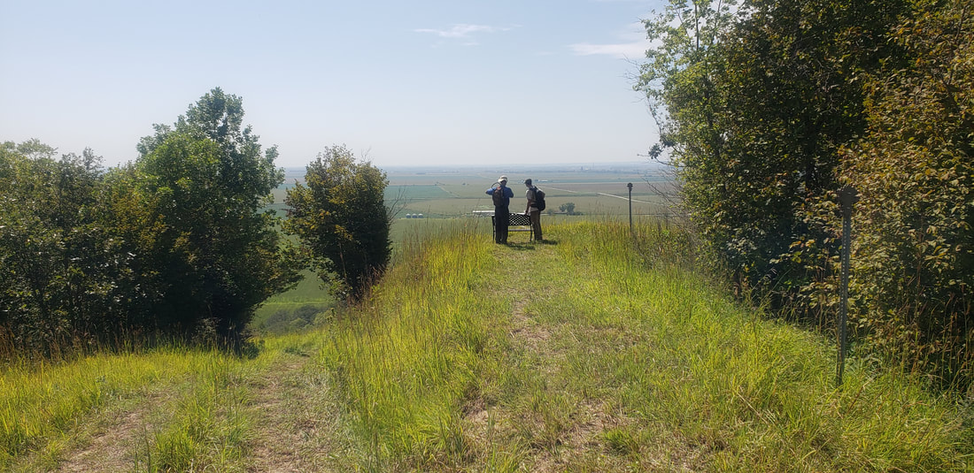
Scenic overlook on the southern extension. Photo by Lance Brisbois.

What do you need to hike Brent's Trail?

Picture
A hiker wearing the essentials for Brent's Trail. Photo by Lance Brisbois.
  • Plenty of water - Potable water is not available along the trail.
  • Sun protection - Most of the trail is exposed to the sun; wear a hat and use sunscreen.
  • Long pants - Many hikers comment that the state forest trails are overgrown. However, Brent's Trail was envisioned as a natural trail through the Loess Hills State Forest, so tall grass and other plants will inevitably encroach on the trail. Wear long plants to protect you from ticks and insects, as well as spiky yucca leaves and other plants like poison ivy.
  • Trekking poles - Stereotypes of flat Iowa are thrown out the window on Brent's Trail—there are over 1,800 feet of elevation gain on the eight-mile route! Bring a pair or trekking poles to help on the steep inclines and declines.
  • Sturdy shoes - See above.
  • Tick and insect protection - Use of some combination of prevention is essential: deet, permethrin, long pants and sleeves, socks tucked into pants, etc.
  • Phone or GPS device - The trail is marked by bur oak trail markers, but it is always prudent to bring a fully charged phone or GPS device to ensure that you are following the trail. Cell reception is generally reliable on ridges but can be limited in hollows, valleys, and under dense tree cover.
Picture
A hiker begins the steep ascent up the southern face of Murray Hill. Photo by Lance Brisbois.

Can you camp along Brent's Trail?

There are no campsites along Brent's Trail, however, dispersed camping is permitted throughout the Loess Hills State Forest. There is no potable water along the trail, so if you plan to camp you will either have to carry all your water or cache water somewhere along the trail. The parking areas (blue address signs on the trail map) are logical places to safely store extra water and supplies.
Picture
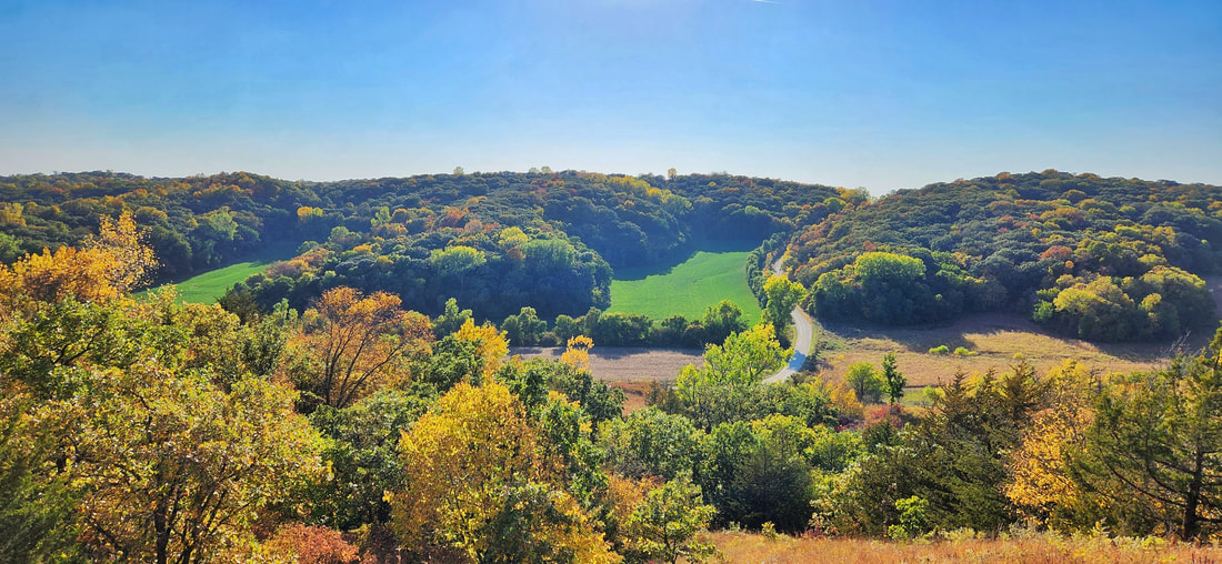
View of 138th Trail from Brent's Trail. Photo by Lance Brisbois.

0 Comments


Leave a Reply.

    Archives

    July 2025
    April 2025
    January 2025
    November 2024
    October 2024
    September 2024
    July 2024
    June 2024
    May 2024
    April 2024
    March 2024
    February 2024
    January 2024
    December 2023
    November 2023
    October 2023
    September 2023
    August 2023
    July 2023
    June 2023
    May 2023
    April 2023
    March 2023
    February 2023
    January 2023
    December 2022
    November 2022
    May 2022
    April 2022
    February 2022
    January 2022
    December 2021
    November 2021
    October 2021
    August 2021
    July 2021
    June 2021
    May 2021
    April 2021
    March 2021
    February 2021
    December 2020
    November 2020
    October 2020
    September 2020
    August 2020
    July 2020
    June 2020
    May 2020
    April 2020
    January 2020
    December 2019
    September 2019
    August 2019
    July 2019
    May 2019
    April 2019
    March 2019
    January 2019
    November 2018
    October 2018
    September 2018
    August 2018
    July 2018
    May 2018
    April 2018

    Categories

    All
    Arts & Culture
    Botany On The Byways
    Community Partnerships
    Hiking The Byways
    Land Stewardship
    Local Foods
    Outdoor Recreation & Tourism
    Water Resources

    RSS Feed

      Newsletter sign-up

    Subscribe to Newsletter

Address

712 South Highway Street 
P.O. Box 189
​Oakland, IA 51560

Contact

Phone: 712-482-3029
General inquiries: [email protected]
Visit our Staff Page for email addresses and office hours.
  • Home
  • About Us
    • Job Openings
    • Who We Are
    • Where We Work
    • What We Do >
      • Community Partnerships
      • Arts and Culture
      • Water Resources
      • Local Foods
      • Outdoor Recreation & Tourism
      • Land Stewardship
  • News
  • Events
  • Donate to Golden Hills